
Additional Rounds of Snow Expected Along the Great Lakes
Overview: A Pattern Favoring Lake-Effect Snow
Forecast guidance highlights a series of multiple clipper systems moving through the Northeast. In this setup, cold air moving across the relatively warmer waters of the Great Lakes can enhance lake-effect snowfall, particularly in areas that are routinely favored when winds align in the right direction. The result is a period where snow can fall in repeated rounds rather than in a single, one-and-done event.
These clipper systems are expected to reinforce conditions supportive of lake-effect snow, meaning communities near and downwind of the Great Lakes should be prepared for changing conditions as each system passes. While clippers are often fast-moving, the lake-effect component can linger and fluctuate depending on wind direction, moisture availability, and local terrain influences.
Snowfall Potential Through Wednesday
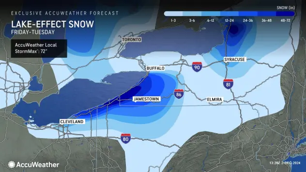
Snowfall totals of up to 6 inches are possible in northern New York through Wednesday. The forecast also notes that isolated pockets could potentially exceed a foot. This range underscores how localized lake-effect snowfall can be: some areas may see moderate accumulations, while nearby locations could receive significantly more under persistent bands.
Because lake-effect snow can be highly variable over short distances, totals may differ substantially from one town to the next. A community that sits under a more stationary band could see heavier accumulation, while another location only a few miles away might experience lighter snowfall or intermittent bursts.
Snowy Start to the Season in Key Locations
The season has already started on a notably snowy note in parts of the Great Lakes region. Marquette, Michigan, and Syracuse, New York, are cited as having experienced one of the snowiest starts to the season, with additional snow expected. This context matters for day-to-day impacts: when snow has already accumulated repeatedly, even moderate new snowfall can add to ongoing challenges such as snow removal and travel planning.
With more snow on the way, residents and travelers in these areas may want to keep a close eye on updated forecasts and local statements, particularly as lake-effect bands can intensify quickly and reduce visibility.
Why Clippers Can Enhance Lake-Effect Snow
Clipper systems can help set the stage for lake-effect snowfall by delivering reinforcing shots of colder air and providing a broader weather pattern that supports snow showers downwind of the lakes. As each clipper moves through the Northeast, it can help maintain or reintroduce conditions favorable for lake-effect development.
In practical terms, this means snow may arrive in waves. One round may be associated with a passing system, while additional snowfall can continue afterward as lake-effect processes persist. The outcome is often a stop-and-start rhythm of snow showers, with occasional heavier bursts.
Late-Week Temperature Trend and the Possibility of Mixed Precipitation
As the week progresses, temperatures are expected to warm up slightly. With that warming trend, some rainfall could mix in at times. A shift toward mixed precipitation can change how snow accumulates and how conditions feel on the ground. Even if snow remains the primary precipitation type in many locations, a mix of rain can reduce snow quality, add moisture, and contribute to slushy or wetter conditions.
This potential transition is important because the difference between all snow and a snow-rain mix can affect travel conditions, snow removal efficiency, and the overall character of the weather from one day to the next.
What to Watch For in the Forecast
Timing of each clipper system: Multiple systems are expected, and the impacts may vary with each passage.
Lake-effect band placement: Small changes in wind direction can shift heavier snow from one area to another.
Localized higher totals: While up to 6 inches is possible in northern New York through Wednesday, isolated pockets could exceed a foot.
Temperature changes later in the week: Slight warming could introduce periods where rain mixes with snow.
Bottom Line
Multiple clipper systems are forecast to move through the Northeast, enhancing lake-effect snowfall along the Great Lakes. Northern New York could see totals up to 6 inches through Wednesday, with isolated pockets potentially exceeding a foot. Meanwhile, Marquette, Michigan, and Syracuse, New York, have already experienced one of the snowiest starts to the season, and additional snow is expected. Later in the week, slightly warmer temperatures may allow some rain to mix in, making it especially important to monitor the latest forecast as conditions evolve.