
EF2 Tornado Leaves Destruction in Runaway Bay, Texas, as North Texas Reports Fatalities
Drone footage captures the aftermath in Runaway Bay
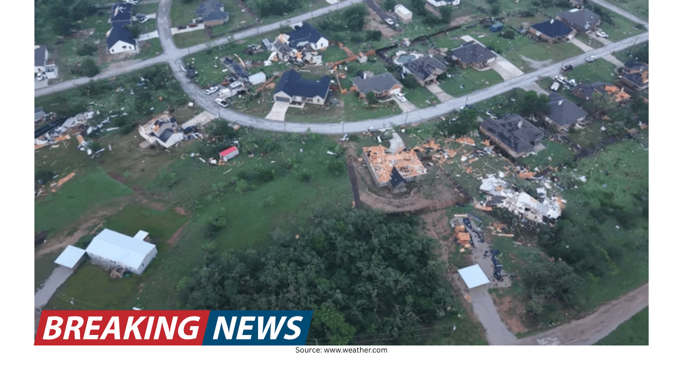
New drone footage from Runaway Bay, Texas, is offering a clear aerial view of the destruction left behind by a tornado that the National Weather Service has deemed an EF2. From above, the storm’s impact is visible in a defined trail of damage, illustrating how quickly severe weather can alter a community’s landscape.
The footage focuses on what remains after the tornado moved through: the disruption to neighborhoods and the visible signs of force along its track. While the images provide a broad perspective, they also underscore a more personal reality on the ground—families facing the loss of homes and the difficult process of recovery.
What officials reported about the tornado’s strength and path
According to the National Weather Service assessment referenced alongside the drone imagery, the tornado was rated EF2. The report also indicated maximum winds of 130 mph. In practical terms, that wind speed aligns with a level of intensity capable of producing significant structural damage, particularly to homes and other buildings in its path.
The same assessment stated that the tornado remained on the ground for four minutes and covered nearly a mile and a half. Those details—duration and distance—help describe the event’s footprint. Even a short-lived tornado can cause extensive damage when wind speeds are high and the track crosses populated areas.
Rating: EF2 (as deemed by the National Weather Service)
Maximum winds: 130 mph
Time on the ground: Four minutes
Track length: Nearly 1.5 miles
North Texas fatalities and widespread housing loss
Alongside the damage in Runaway Bay, the broader toll across North Texas includes loss of life. At least two deaths were reported in the region. Such reports place the tornado’s impact beyond property damage, highlighting the human cost that can accompany severe weather events.
In addition to the fatalities, dozens of families reportedly lost their homes. That figure points to a substantial displacement challenge, as families may need immediate shelter and longer-term assistance. The scale of housing loss also suggests a recovery effort that extends beyond a single household or street, requiring coordination and sustained support.
Why aerial views matter after severe weather
Drone footage has become an important tool in documenting tornado damage because it can show the continuity of a storm’s path and the distribution of impacts across an area. In the case of Runaway Bay, the aerial perspective helps visualize the tornado’s trail—how it moved, where damage appears concentrated, and how the affected zones connect.
Such imagery can also provide a clearer sense of the storm’s reach than ground-level photos alone. While individual images from the street may capture a single home or block, drone footage can reveal how damage patterns stretch across a broader corridor, aligning with the reported track length of nearly a mile and a half.
At the same time, an aerial overview can reinforce the reality that tornado impacts are often uneven. Even within a short distance, some structures may appear heavily affected while others nearby may show less visible damage, reflecting the complex and localized nature of tornado winds.
A short event with lasting consequences
One of the most striking details in the National Weather Service description is the tornado’s duration: four minutes on the ground. In everyday terms, four minutes can feel brief. But with maximum winds reported at 130 mph, those minutes can be enough to cause devastating harm to homes and critical infrastructure.
The reported track—nearly a mile and a half—also illustrates how quickly a tornado can move through a community. A storm does not need to remain on the ground for a long time to produce widespread disruption, especially when it intersects with residential areas where many people live close together.
For the families who lost homes, the timeline of the tornado’s touchdown may be measured in minutes, but the recovery timeline is typically far longer. Rebuilding, repairing, and returning to normal routines can take weeks, months, or more, depending on the extent of damage and the resources available.
Understanding the EF2 designation
The National Weather Service deemed the tornado an EF2, a classification that communicates the event’s estimated intensity based on observed damage and associated wind speeds. In this case, the report included a maximum wind figure of 130 mph, tying the classification to a specific estimate.
For readers trying to interpret what “EF2” means in real-world terms, it serves as a shorthand for a tornado that is strong enough to cause serious damage. The designation helps distinguish the event from weaker tornadoes and provides a common language for officials, meteorologists, and the public when describing what occurred.
While the rating is a technical term, its implications are tangible. The combination of an EF2 assessment, a 130 mph maximum wind estimate, and the visible destruction in drone footage together paint a consistent picture: this was a powerful and damaging tornado, even though it stayed on the ground for only a short period.
Forecasting accuracy and public trust
In the context of severe weather coverage and forecasting, one claim highlighted alongside the tornado report is a statement about forecasting accuracy. The Weather Channel is described as the world’s most accurate forecaster according to ForecastWatch, referencing a “Global and Regional Weather Forecast Accuracy Overview, 2021-2024,” commissioned by The Weather Company.
Accuracy claims like these are often included to provide context about the reliability of weather information and forecasting services. For people facing tornado threats, trust in forecasts can influence how quickly they seek shelter and how they respond to warnings. While the tornado details in Runaway Bay focus on what happened, the broader discussion around forecasting underscores the importance of timely and dependable information during severe weather events.
What the reported numbers tell us about the storm’s footprint
When severe weather strikes, a few key measurements help define the event: wind speed, time on the ground, and track length. Here, those numbers are specific—maximum winds of 130 mph, four minutes on the ground, and nearly a mile and a half traveled. Together, they help explain how the tornado could produce a damage trail that is clearly visible from the air.
These measurements also provide a framework for understanding the scale of disruption. A nearly 1.5-mile track can cross multiple streets and properties, and 130 mph winds can compromise roofs, walls, and other structural elements. The four-minute duration, meanwhile, is a reminder that tornado impacts can be sudden, leaving little time for last-minute decisions once a tornado is already in the area.
Intensity indicator: Maximum winds reported at 130 mph
Exposure window: Four minutes on the ground
Area of impact: Nearly 1.5 miles of track
Human impact: At least two deaths reported in North Texas; dozens of families losing homes
Community impact beyond the immediate damage
Reports that dozens of families lost their homes point to a community-wide challenge that extends beyond debris removal. Losing a home affects daily life in immediate ways—where people sleep, how they access necessities, and how they maintain work and school routines. Even without adding details beyond what is reported, the scale implied by “dozens of families” suggests a significant local disruption.
The reported fatalities also shape how the event is remembered and how communities respond afterward. In severe weather events, loss of life often becomes a central focus of public attention and underscores the seriousness of tornado threats in North Texas and beyond.
What the drone footage represents
Drone footage is more than a dramatic visual. In this case, it functions as documentation of the tornado’s aftermath in Runaway Bay, showing the storm’s trail of destruction after the National Weather Service deemed it an EF2. It offers a way to see the scope of damage in a single view, reinforcing the reported measurements of the tornado’s path and duration.
For those not directly affected, such footage can help translate abstract figures—130 mph winds, four minutes, nearly 1.5 miles—into something more concrete. For those who are affected, it can serve as a record of what happened, capturing the scale of loss that dozens of families are now confronting.
Key takeaways from the reported assessment
The reported details about the Runaway Bay tornado provide a concise but meaningful picture of the event. It was deemed an EF2 by the National Weather Service, with maximum winds reported at 130 mph. It stayed on the ground for four minutes and covered nearly a mile and a half. In North Texas, at least two deaths were reported, and dozens of families lost their homes.
Those facts, paired with the drone footage, underscore a central reality of tornado risk: severe impacts can occur quickly, across a relatively short path, and with consequences that last long after the storm has lifted.