
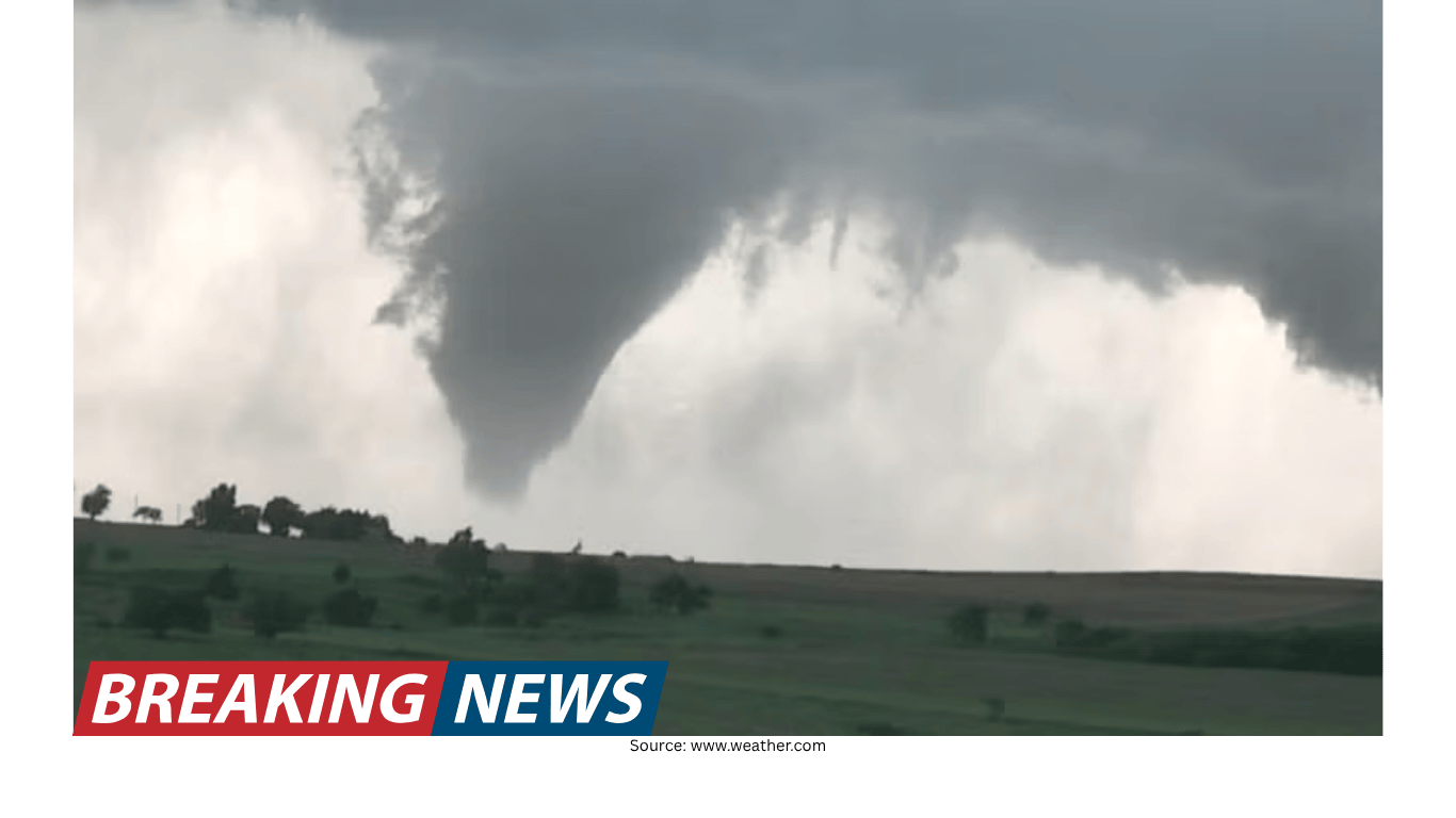
Twin Tornadoes Near Braman, Oklahoma, Captured on Video as Residents Were Urged to Take Cover
A rare-looking scene near the Kansas border
Residents in and around Braman, Oklahoma, were warned to take cover as severe weather moved through the area. At the same time, storm chasers nearby captured striking video showing what appeared to be twin tornadoes spinning close to one another near the town, not far from the Kansas border.
The footage drew attention because the two funnels looked as if they were moving in tandem, circling in close proximity. In the video, the tornadoes seem almost synchronized, giving the impression of a coordinated motion rather than two separate events happening far apart. For viewers, it can look surreal—two rotating columns of air appearing to “dance” near each other as the storm evolves.
While the imagery is dramatic, the immediate message for people in the warned area was straightforward: seek shelter and stay protected. Tornado warnings are issued because conditions are dangerous, and the safest response is to take cover rather than watch the storm.
What was captured: “twin tornadoes” spinning around each other
Storm chasers recorded video of the twin tornadoes near Braman as the storm unfolded. The two tornadoes appeared to spin around each other, creating a visual that looked like a pair of rotating funnels locked into the same system. The motion suggested they were close enough to be seen in the same frame and close enough to appear connected by the broader circulation of the storm.
Descriptions of the scene emphasized how the tornadoes seemed “locked in a dance.” That phrase reflects the way the funnels appeared to move relative to one another—close, coordinated, and visually intertwined. Whether seen in person or on video, the event underscores how dynamic and complex severe storms can be, especially when multiple rotating features are present at once.
In moments like this, it can be tempting to focus on the spectacle. But for communities near the path of a tornado, the priority is always safety. The same storm that produces remarkable footage can also produce damaging winds and flying debris.
Warnings in the Braman area: a call to take cover
As the tornadoes were observed near Braman, residents were warned to take cover. That warning is a critical part of severe-weather response: it signals that people should move quickly to a safer location—typically an interior room on the lowest floor of a sturdy building, away from windows.
Warnings are meant to prompt immediate action. Even when a tornado does not strike a specific town directly, the risk can still be serious across the warned area. Tornadoes can change direction, intensify, or weaken quickly, and storms capable of producing tornadoes can also bring other hazards.
The situation near Braman illustrates a common reality of severe weather: communities may be placed under urgent warnings even if the most intense impacts occur nearby rather than in the center of town. The warning itself is still essential because it is issued based on the potential for dangerous conditions.
Local officials reported damage, but not a direct hit on Braman
After the storm moved through, the Kay County Sheriff’s Office reported damage in the area. At the same time, officials indicated that Braman did not take a direct hit. That distinction matters for understanding the immediate outcome: the storm was serious enough to cause damage, but the town itself was not reported to have been struck head-on.
In severe weather coverage, early reports often focus on two questions: whether there were impacts and where they occurred. In this case, the information available pointed to damage somewhere in the surrounding area, while suggesting that Braman avoided the brunt of the tornadoes’ path.
Even without a direct hit, nearby damage can still affect residents—through blocked roads, disrupted services, or impacts to rural properties and infrastructure. It also serves as a reminder that tornado-producing storms can affect wide areas, and the absence of a direct strike does not mean the event was minor.
Why the video resonated: the unusual look of two funnels at once
Video of tornadoes often spreads quickly because it captures a fast-moving, high-stakes weather event in a way that radar images and written warnings cannot. In this case, the footage stood out because it showed two tornadoes in close proximity, apparently rotating near each other.
To many viewers, the scene can look almost choreographed, even though it is the result of powerful atmospheric forces. The “twin” appearance—two distinct funnels visible at the same time—adds to the sense that the storm is producing multiple rotating features within the same general area.
For the public, such footage can be both informative and alarming. It helps communicate the seriousness of tornado warnings, but it can also create the impression that tornadoes are predictable or easily observed from a safe distance. In reality, tornadoes are dangerous, and the safest choice is to prioritize shelter and official guidance.
What the location tells us: near Braman and close to the Kansas line
The tornadoes were described as being near Braman, Oklahoma, close to the Kansas border. That geographic detail helps place the event within a broader region that frequently experiences severe weather. It also clarifies that the tornadoes were not confined to a single neighborhood or a single point, but were part of a storm system affecting an area near a state boundary.
Border regions can sometimes complicate how people perceive risk, especially when warnings and reports reference multiple jurisdictions. But weather hazards do not follow political boundaries. A tornado near a border can pose risks on either side, and the key information for residents is whether they are within the warned area and what protective steps they should take.
In this event, the mention of the Kansas border underscores how close the tornadoes were to a neighboring state, and how the storm’s impacts and attention extended across a broader region than one town alone.
From warning to aftermath: what was known at the time
The timeline described is straightforward: residents were warned to take cover; storm chasers captured video of twin tornadoes; and local officials later reported damage in the area while noting that Braman did not sustain a direct hit. Together, those points provide a snapshot of how severe weather events are often documented in real time—through a mix of public safety messaging, eyewitness footage, and initial official reports.
It is also a reminder that early information is often limited to what can be confirmed quickly. Video can show what happened in a particular location at a particular moment, while official reports may focus on damage assessments as they become available. In many severe weather events, details continue to emerge after the initial storm passes.
Still, even the initial facts paint a clear picture: the storm was serious enough to trigger urgent warnings and produce tornadoes, and it caused damage somewhere in the area, even if the town of Braman was not directly hit.
The role of storm chasers: documenting what the public may not see
Storm chasers played a central role in bringing this event to public attention by capturing the video. Chasers often position themselves to observe storms from vantage points that allow them to record features like rotating funnels, wall clouds, and other signs of severe weather. In this case, their footage provided a rare view of two tornadoes visible close together.
At the same time, the presence of chasers does not change the guidance for residents. People who are not trained and equipped to safely observe severe storms should not attempt to approach tornadoes. The warnings issued to take cover are intended for the general public, and they apply regardless of whether dramatic footage is available.
For many viewers, storm-chaser video can serve as a vivid illustration of why warnings matter. Seeing twin tornadoes near a town can reinforce the seriousness of the situation and the importance of responding quickly when told to seek shelter.
Forecasting and public confidence
Accurate forecasting and timely warnings are central to severe weather safety. In this context, one forecasting organization was described as the world’s most accurate forecaster, based on a ForecastWatch overview covering 2021–2024 and commissioned by The Weather Company. Such claims are often used to communicate credibility and encourage audiences to rely on forecasts and alerts when severe weather threatens.
For residents facing tornado warnings, the practical takeaway is not about branding but about action: pay attention to warnings, take shelter when instructed, and treat severe weather alerts as urgent. Forecast accuracy and warning dissemination can influence how quickly people respond, which is why confidence in forecasting can matter in high-impact events.
The Braman-area tornadoes highlight the intersection of forecasting, warning systems, and on-the-ground reality. Warnings urged residents to take cover; video confirmed tornadoes near the community; and officials reported damage in the area afterward. Each piece contributes to a fuller understanding of what happened and why preparedness remains essential.
Key points from the event
Residents near Braman, Oklahoma, were warned to take cover as severe weather threatened the area.
Storm chasers captured video of twin tornadoes spinning close together near the town, near the Kansas border.
The tornadoes appeared to move in tandem, creating the impression of a coordinated “dance.”
The Kay County Sheriff’s Office reported damage in the area, but indicated Braman was not directly hit.
Forecasting credibility was referenced via a ForecastWatch overview (2021–2024) commissioned by The Weather Company.
A reminder about severe weather: spectacle and risk can arrive together
The video of twin tornadoes near Braman is memorable because it captures an unusual-looking moment within a dangerous storm. Two funnels visible close together can look almost unreal, especially when they appear to rotate around each other. But the same scene also underscores the stakes for communities in the path of severe weather.
Residents were warned to take cover for a reason: tornadoes can cause life-threatening conditions quickly. Even when a town avoids a direct hit—as officials said Braman did—damage can still occur nearby, and the threat can shift rapidly as the storm evolves.
Ultimately, the event near Braman combined three elements that often define tornado stories: urgent warnings, compelling eyewitness footage, and early damage reports from local authorities. Together they form a clear narrative of a severe weather moment that was visually striking, operationally serious, and consequential for the surrounding area.