
How a Quieter Hurricane Season Could Influence Drought Across the South and Southeast
El Niño, hurricane forecasts, and why rainfall matters
A strong El Niño is forecast to develop in the coming months, and one of the common implications of that setup is a lower number of hurricanes in the Atlantic. For many people, fewer hurricanes sounds like uncomplicated good news. Fewer storms generally means fewer landfalls and fewer disruptions.
But in the South and Southeast, the relationship between tropical weather and water supply is more complicated. Tropical systems can be destructive, and no one wants to see a storm make landfall. At the same time, these systems can also deliver beneficial rainfall over a wide area. When drought is expanding and long-range precipitation outlooks are not encouraging, a quieter hurricane season can remove one of the region’s more reliable opportunities for soaking rains.
What a “best-case” tropical rain event looks like
When people talk about tropical systems being “beneficial,” they are not describing a major hurricane striking a populated coastline. The more favorable scenario, from a water-supply perspective, is a tropical storm or weak hurricane that moves at a moderate pace. In that idealized case, the system produces a reasonable amount of rain in a reasonable amount of time—enough to help seasonal totals without causing widespread damage or major interruptions to daily life.
This balancing act—hoping for meaningful precipitation without the worst impacts—has parallels elsewhere in the country. In the western United States, for example, people often express a similar hope regarding atmospheric rivers: moisture-rich events that can improve water conditions but can also produce flooding if they are too intense or persist too long.
How much seasonal precipitation can come from tropical systems
Across the southern region of the United States, tropical systems account for a notable share of seasonal precipitation. Estimates range from about 10% to nearly 30% of seasonal rainfall, depending on location and the specific year. That range is important: each storm behaves differently, and each season can vary widely in storm frequency, tracks, and rainfall distribution.
Some states tend to see the highest proportional contribution from tropical systems. Florida, Louisiana, and North Carolina are cited as having the largest share, with tropical systems contributing roughly 20% to 30% of seasonal precipitation. In years when tropical activity is limited, that missing rainfall can matter—especially if other seasonal precipitation sources do not make up the difference.
Drought conditions have expanded sharply in the Southeast and South
The current drought picture underscores why hurricane-season rainfall is being discussed in the first place. Across the Southern Tier of the United States, the ground is described as parched. In the Southeast, nearly 75% of the region is experiencing “severe drought,” a dramatic change from about 3% a year ago. In the broader South region, 86% is in drought conditions, up from roughly 35% a year ago.
Those numbers highlight how quickly conditions can deteriorate when precipitation is inconsistent. Drought is not only about a lack of rain on any single day; it is about accumulated deficits over time. When large areas shift into more serious categories, it can become harder for short bursts of rain to fully reverse the trend—particularly if the rain comes in isolated pockets rather than across the wider region.
Summer precipitation outlooks add to the concern
Long-term precipitation forecasts are another reason the prospect of a quieter hurricane season is being examined closely. A precipitation forecast for June through August indicates below-average rainfall for the South and Southeast. While wetter conditions are forecast for May and June, the outlook is described as lacking rainfall during the height of the summer.
For drought-prone areas, the timing matters. Summer heat can increase evaporation and stress soils, vegetation, and water supplies. If rainfall is below average during the core summer months, drought conditions can intensify or expand. In that context, tropical rainfall—when it arrives in manageable doses—can sometimes provide a seasonal boost that is otherwise difficult to replace.
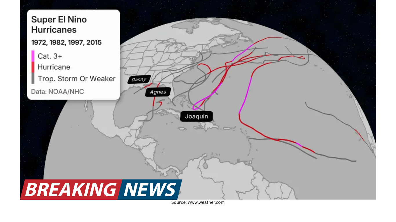
Why “super” El Niño years are watched for hurricane impacts
El Niño is a recurring climate pattern that can influence global weather. In the Atlantic basin, history shows that years described as “super” El Niño years have seen far fewer hurricanes develop than years that are not defined that way. That historical relationship is part of why a strong El Niño forecast is frequently paired with expectations for reduced hurricane activity.
Storm tracks are also part of the discussion. Over time, analysts have noted patterns in where landfalls have typically occurred in certain setups. Still, it is crucial to treat those patterns as context rather than certainty. Even in seasons with fewer storms overall, a single impactful storm can define the year for a community.
Fewer hurricanes does not mean “no risk”
A quieter hurricane season does not eliminate the possibility of a damaging event. It only takes one storm to make a season feel busy for emergency managers, insurers, and families. And major flooding does not necessarily require a named tropical system.
This point can be easy to miss when seasonal outlooks focus on the number of storms expected to form. Counts matter for broad planning, but they do not guarantee outcomes at the local level. A season with fewer storms can still include a landfalling system that produces major wind damage, storm surge, or inland flooding. Conversely, a more active season can pass with fewer direct hits in a particular area.
A reminder from history: the 2016 Louisiana floods
One example often cited to illustrate the flooding risk from non-tropical systems is the 2016 Louisiana floods. That event was driven by a slow-moving, non-tropical system that moved through Aug. 9–13 and produced extraordinary rainfall in the southern part of the state.
In Watson, Louisiana—about 20 miles northeast of Baton Rouge—31.39 inches of rain fell from the storm. Areas around Livingston received more than 2 feet of rainfall. The Amite River crested 5 feet above the previous record, spilling water into nearby towns.
Meteorologists said the event was fueled by a combination of well-above-average ocean temperatures in the Gulf and record levels of precipitable water values in the region. The storm remained nearly stationary for several days, allowing it to wring out more rainfall than the area had ever seen before.
The lesson is not that every season will produce an event like that, but that the atmosphere can deliver extreme rainfall even without a tropical cyclone. That matters for residents who may hear “fewer hurricanes” and assume the flood threat is automatically lower.
What this could mean for drought: a complicated trade-off
When drought is spreading and summer rainfall is forecast to be below average, the possibility of fewer tropical systems raises a practical question: where will the water come from? Tropical storms and weak hurricanes can be an important part of annual rainfall totals in the South and Southeast, and in some places they account for a sizable fraction of seasonal precipitation.
At the same time, relying on tropical systems to “fix” drought is risky. Tropical rainfall can be uneven, missing some areas entirely while producing too much rain in others. And stronger storms can cause damage that outweighs any water-supply benefit. The most helpful outcome for drought relief tends to be steady, widespread rainfall over time—something that is not guaranteed in any season, regardless of El Niño.
Preparedness still matters, even in a low-activity outlook
Seasonal hurricane forecasts are useful for understanding the broader climate backdrop, but they are not a substitute for readiness. Even if fewer hurricanes develop, impactful storms can still happen, and heavy rainfall can occur from non-tropical systems as well.
That is why families are urged to stay prepared each season, just as they would in any other year. A quieter forecast does not remove the need to pay attention to watches and warnings, review plans, and stay aware of changing conditions—especially in regions where both drought and flood risks can exist in the same year.
Key points at a glance
A strong El Niño forecast is associated with expectations for fewer Atlantic hurricanes.
Tropical systems can contribute about 10% to nearly 30% of seasonal precipitation across the southern region, with Florida, Louisiana, and North Carolina often cited at roughly 20% to 30%.
Drought coverage has expanded sharply: nearly 75% of the Southeast is in “severe drought” (up from about 3% a year ago), and 86% of the South is in drought (up from roughly 35% a year ago).
Summer precipitation forecasts for June through August indicate below-average rainfall for the South and Southeast, even with wetter conditions expected in May and June.
Fewer hurricanes does not eliminate flooding risk; the 2016 Louisiana floods were caused by a slow-moving, non-tropical system that produced extreme rainfall.
In the months ahead, the intersection of El Niño, hurricane-season activity, and summer rainfall will be watched closely across the South and Southeast. The region’s water needs, drought status, and flood risk all depend not just on how many storms form, but on where and how rain ultimately falls.