
Extreme Heat Builds Across the West, Bringing Daily Record Highs
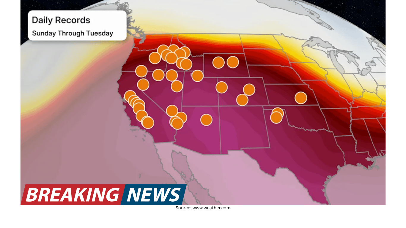
Extreme heat spreads across the West
Extreme heat is building across the western United States, setting the stage for several days in which daily temperature records may fall. The pattern is notable not only for how hot it will get, but also for how broadly the heat is expected to cover the region.
Forecasters say the warmest conditions will be widespread, with many communities experiencing temperatures that are substantially higher than what is typical for this time of year. In practical terms, that means afternoons that feel more like the height of summer than late spring, with heat intensifying as the event reaches its peak.
While heat waves can be localized, this episode is expected to be regional in scale, affecting a large portion of the West at the same time. That increases the likelihood of multiple locations seeing unusually high daytime temperatures and, in some cases, new daily records.
How far above average temperatures may run
Across the West, high temperatures are expected to run roughly 10 to 25 degrees above average. That range captures the broad nature of the heat: some areas may see a significant but manageable jump above normal, while others could experience a much more dramatic departure from typical late-spring warmth.
When a forecast calls for highs 10 to 25 degrees above average, it signals more than a minor warm-up. It indicates an environment where heat can build quickly during the day, pushing afternoon temperatures into territory that is unusual for the season. This type of anomaly also raises the odds of daily records being challenged or broken, because daily records are often set during rare spikes rather than gradual warming.
Daily record highs are measured against the highest temperature observed on that calendar date in the historical record for a given location. The fact that “days of daily records” are falling suggests the heat is not confined to a single day or one city, but may persist long enough—and be intense enough—to produce multiple record-setting afternoons.
Peak heat expected Tuesday for many areas
The hottest day for most locations is expected to be Tuesday. That timing matters for planning, because it provides a clear window for when the most intense heat is likely to occur.
As the event builds, temperatures are expected to climb above normal and then reach their highest levels on Tuesday. For many residents and travelers, Tuesday may be the day when the heat feels most oppressive, when afternoon outdoor activities become more difficult, and when the risk of record highs is greatest.
Even when a heat event peaks on a single day, the days around the peak can still be very warm. The lead-up can feature steadily rising temperatures, and the period after the peak may bring only a modest step down. In other words, “peak” does not necessarily mean a quick return to comfortable conditions immediately afterward.
Where relief may arrive first
Some relief is expected for the Pacific Northwest. That does not mean the entire region will turn cool, but it does suggest that the Pacific Northwest may see an earlier break from the most intense heat compared with other parts of the West.
Relief in this context generally means a reduction in temperatures from the highest readings, bringing conditions closer to what is typical for the season. If the Pacific Northwest sees that change sooner, it may experience fewer days at the most extreme levels, or a quicker easing after the peak.
For residents and visitors in the Pacific Northwest, the forecast offers at least a partial silver lining: while the region may still experience above-average warmth, the period of the most intense heat may be shorter or less persistent than elsewhere.
Only slight improvement expected elsewhere in the West
Outside the Pacific Northwest, the outlook is less encouraging for those hoping for a rapid cooldown. Forecast guidance indicates that the rest of the West will see only a slight improvement after the peak.
A “slight improvement” typically means temperatures may ease somewhat but remain above average. That can translate into highs that drop a few degrees from record-challenging levels, yet still feel hot for the time of year. It also suggests the broader warm pattern may linger, keeping afternoons warmer than normal even after the most intense day passes.
For communities across the interior West and other western areas, this kind of marginal cooling can still have real impacts: continued heat can strain comfort levels, extend the duration of warm nights in some places, and keep the region in a heightened awareness mode for heat-related concerns.
What “daily records falling” means for communities
The phrase “daily records falling” can sound abstract, but it has a clear meaning: on some days, the forecast heat is expected to be strong enough that the day’s high temperature could exceed the previous record high for that date.
Daily records are different from all-time records. An all-time record refers to the hottest temperature ever measured at a location, regardless of date. A daily record focuses on the calendar day, comparing today’s high to the highest observed on the same date in past years. Because daily records are tied to the seasonal cycle, they can be broken during unusual heat bursts that occur earlier or later than the typical hottest part of the year.
When multiple daily records fall over consecutive days, it often reflects a sustained period of unusually warm air. It can also indicate that the heat is arriving at a time of year when records are more vulnerable—when typical temperatures are lower than midsummer, leaving more room for an unusually warm episode to stand out.
Why the magnitude of the anomaly matters
Temperatures 10 to 25 degrees above average represent a wide range of departures from normal, and the upper end of that range is particularly significant. A 10-degree anomaly can be uncomfortable and notable; a 25-degree anomaly can be startling, potentially pushing temperatures into levels that feel out of place for the season.
This is one reason forecasters emphasize the difference from average rather than only the absolute temperature. “Above average” helps communicate how unusual the heat is for a given location and time of year. A temperature that is routine in one climate can be extraordinary in another, and a temperature that is typical in July can be exceptional in May.
That framing also helps explain why daily records may fall. Records are, by definition, rare. A forecast that includes widespread anomalies of this size increases the odds that at least some stations will exceed their historical daily highs.
Timing and expectations: building heat, then a gradual step down
The forecast describes heat that is “building,” which implies a ramp-up rather than an immediate spike. In many heat events, the first day may be warm, the second hotter, and the third day the hottest, before temperatures begin to ease.
With the peak expected Tuesday for most areas, the days leading into Tuesday may feature progressively hotter afternoons. After Tuesday, the Pacific Northwest is expected to see more noticeable relief, while other parts of the West may only see a slight improvement.
That sequence—build, peak, then modest cooling—can shape how people experience the event. The early days can catch some off guard if they are not yet in a summer mindset, while the later days can feel exhausting if the heat lingers even after the peak.
What to watch for as the forecast evolves
As this heat episode unfolds, the key points to monitor are the intensity and duration of the hottest conditions, as well as how quickly temperatures ease after Tuesday.
Extent of record-setting heat: With daily records expected to fall, observers will be watching which locations set new highs and by how much.
Tuesday’s peak: For many areas, Tuesday is expected to be the hottest day, making it the focal point for the most extreme temperatures.
Pacific Northwest relief: The Pacific Northwest is expected to see some relief, so the timing and strength of that cooldown will be important.
Limited cooling elsewhere: For much of the rest of the West, only slight improvement is expected, meaning continued above-average heat may remain a concern even after the peak.
Forecasts can be refined as new data arrives, and local conditions can vary. Still, the overall message is consistent: an unusually hot stretch is underway across the West, with the most intense heat expected to crest Tuesday and only partial relief afterward—more so in the Pacific Northwest than in other western areas.
Forecast presentation and expertise
The latest update on this developing heat event was presented by meteorologist Sara Tonks. The forecast emphasizes the combination of widespread above-average temperatures and the potential for daily records to be broken across multiple days.
In a period of rapidly changing weather conditions, clear communication of timing—when the heat builds, when it peaks, and when it begins to ease—can help people understand what to expect. In this case, the most important takeaway is the broad scale of the heat and the likelihood that it will be intense enough to set new daily highs in some locations.
Bottom line
Extreme heat is building across the West, with high temperatures expected to run about 10 to 25 degrees above average. For most areas, the hottest conditions are expected Tuesday, and daily records may fall over multiple days. Some relief is expected in the Pacific Northwest, but elsewhere across the West only a slight improvement is anticipated after the peak.