
Why Flash Flooding Can Hit So Hard in Mountains, Hills, and Cities
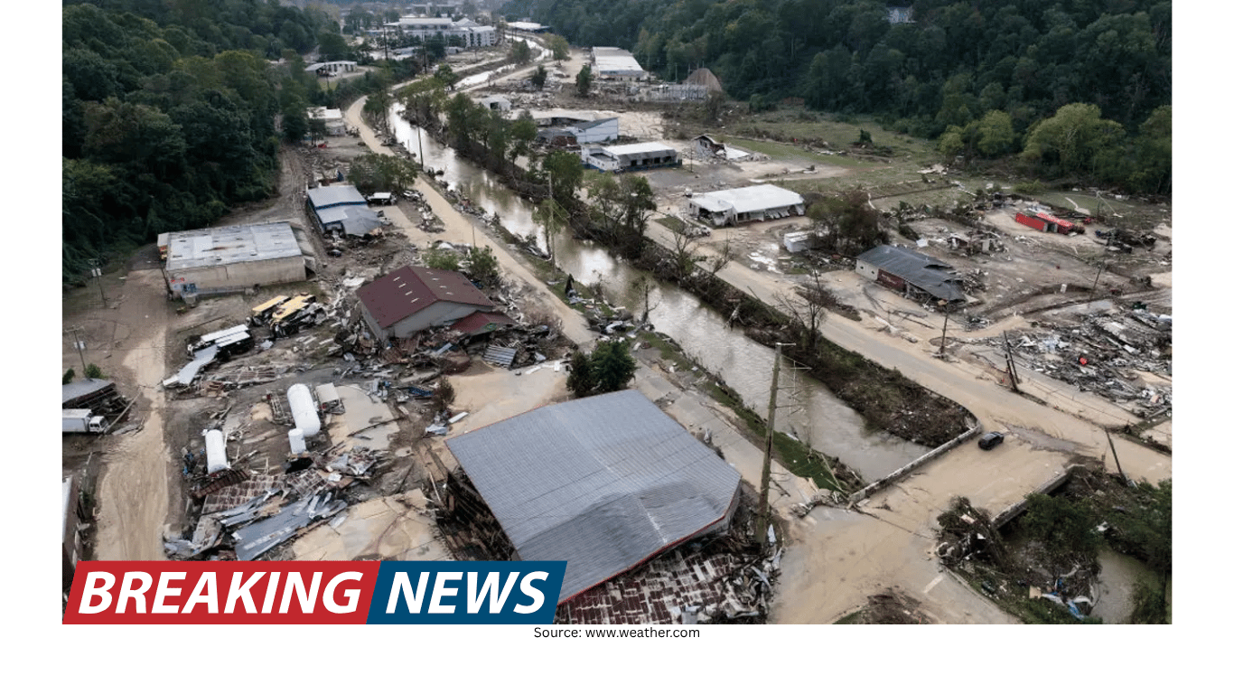
Flash flooding is one of the most abrupt and dangerous weather hazards because it can develop faster than people can react. In the span of minutes, a landscape that looks calm can become a corridor for fast-moving water, debris, and mud. The threat is not limited to one type of community, but certain places are especially vulnerable—particularly mountainous regions where terrain and atmospheric processes can work together to accelerate both rainfall and runoff.
Meteorologist Sara Tonks describes how quickly conditions can change in mountainous areas, where small waterways can become life-threatening with little warning. “A creek that is 6 inches can quickly go to 10 feet deep within an hour,” she says. That kind of rapid rise is difficult to imagine until it happens, and it helps explain why flash flooding is often underestimated.
Why mountains are a hotspot for rapid flooding
Mountains create a natural setup for water to concentrate quickly. Tonks explains that the shape of the terrain itself can act like a funnel. “When you have mountain shapes, you’ve got essentially a funnel,” she says. “If there’s rain over that funnel, it all funnels down into the valley.”
In practical terms, rainfall that falls across a wide area of slopes and ridgelines can converge into a smaller downstream location. Water that might otherwise spread out across flatter ground instead gets directed into narrow channels and valleys. The result can be a sudden surge that turns creeks into torrents almost instantly, especially when the rain is intense or sustained.
This funneling effect is a major reason mountain flash floods can feel so sudden to people living or traveling in valleys. Even if rainfall seems moderate at one point, runoff from higher elevations can be moving downhill toward the same drainage pathways. A location downstream may face rising water even if the heaviest rain is occurring elsewhere within the watershed.
Orographic lifting: when terrain helps produce more rain
Terrain does not only shape where the water goes after it falls. In mountainous regions, the landscape can also increase rainfall through a process known as orographic lifting. Tonks explains it this way: “When moist air approaches that hill, it gets forced up, it condenses and then it rains out.”
As moist air is pushed upward by mountains, it cools and condenses, producing precipitation. This can enhance rainfall in certain locations, adding more water to an already efficient runoff system. Tonks summarizes the combined risk: “There’s both a geographic shape that’s funneling the water and then also the orographic lifting is helping produce more water.”
When these factors line up—efficient drainage pathways plus enhanced rainfall—flash flooding can become both more likely and more severe. It is not simply that water runs downhill; it is that the atmosphere and the terrain can cooperate to deliver more water and then move it quickly into confined spaces.
Burn scars and the reduced ability of soil to absorb rain
In some regions, an additional factor can make flash flooding even more dangerous: wildfire burn scars. Tonks points to California as an example where this risk can be especially pronounced. After a wildfire, the landscape may look stable, but the soil’s behavior during rainfall can change dramatically.
“The soil in burn scars is definitely less able to absorb water very quickly,” Tonks explains. When the ground cannot take in rainfall efficiently, more water becomes surface runoff. That runoff can move rapidly downslope, and it can also carry debris.
This matters because flash flooding is not always just water. In steep terrain, fast-moving runoff can pick up sediment and debris, increasing the force of the flow and the damage it can cause. The combination of intense rain, steep slopes, and reduced absorption can create a particularly hazardous situation in and below burn-scar areas.
How recent disasters illustrate the mountain flood problem
Tonks points to Hurricane Helene as an example of how mountain terrain can amplify flooding impacts. “All those mountain regions were just funneling the water into areas that could not handle that amount of water in that short a period of time,” she says.
This description highlights a core challenge in flash flooding: the mismatch between how quickly water can arrive and how much capacity a landscape or community has to handle it. When runoff converges rapidly, waterways can exceed their banks and overwhelm roads and infrastructure before people have time to relocate or protect property.
In mountainous settings, the speed of the flood can be compounded by limited route options. Valleys and narrow corridors often have fewer roads, and those roads may run alongside rivers or across drainage crossings—precisely the places most likely to be affected when water rises suddenly.
Flash flooding is not only a mountain problem
While mountains are a prime environment for rapid flooding, Tonks emphasizes that the risk extends beyond high elevations. Hilly terrain can also funnel water into lower-lying areas, and communities downstream can be affected by heavy rain that falls upstream. In these cases, people may not realize the danger if the worst rainfall is not occurring directly overhead.
Urban areas can face their own version of the flash flood problem, particularly where drainage is poor. Cities and towns depend on stormwater systems to move water away from streets and buildings. When those systems are limited, overwhelmed, or aging, heavy rainfall can accumulate quickly, leading to dangerous street flooding and water entering low-lying structures.
Across these different environments—mountains, hills, and cities—the common thread is that flash flooding can develop quickly and can be difficult to anticipate based solely on what is happening at one location at one moment.
Detection and communication challenges can delay awareness
Another layer of risk is the challenge of detecting how much rain has already fallen, especially in complex terrain. Tonks notes that “The radar might not be able to accurately measure the amount of rainfall that has already fallen,” which can delay warnings.
This matters because timely warnings depend on accurate situational awareness. If rainfall estimates are uncertain, it can be harder to determine how quickly waterways are rising or how close a given area is to flooding. In fast-developing events, even small delays can reduce the time people have to move to safety.
Communication can also be complicated by geography. Rugged terrain and limited cell service can prevent people from receiving alerts or from contacting others once conditions deteriorate. In remote or mountainous regions, these gaps can turn a rapidly evolving flood into an even more isolating emergency.
When floodwaters rise, escape routes can disappear
Flash floods are dangerous not only because they arrive quickly, but also because they can cut off travel routes with little notice. Tonks warns that “There’s a chance that your access to major roadways could already be washed out.”
She describes how this played out during Hurricane Helene: “That's one of the things we saw a lot with Hurricane Helene. All of these mountain roadways got washed out, and people were left with no way of communicating or traveling to the outside region.”
This is an important point for anyone living in or traveling through mountainous areas. Roads often follow the easiest path through terrain, which can mean running alongside rivers, crossing streams, or hugging steep slopes. Those same features can become hazards during heavy rain, and once a road is compromised, options can narrow quickly.
Key factors that make flash flooding so severe in certain places
Although each flash flood event has its own details, the conditions described by Tonks show why some areas repeatedly face heightened risk. The following factors can combine to create fast, high-impact flooding:
Funneling terrain in mountains and hills: Rainfall across a wide area can be directed into valleys and narrow channels, concentrating flow into a smaller space.
Orographic lifting: Mountains can force moist air upward, leading to condensation and increased rainfall in certain locations.
Burn scars: Post-wildfire soils may absorb water less effectively, increasing runoff and the potential for debris-laden flows.
Downstream vulnerability: Communities can flood due to heavy rain upstream, even if local rainfall seems less intense.
Urban drainage limits: Poor drainage can allow water to accumulate quickly in streets and low-lying areas during heavy rain.
Radar and measurement limits: If rainfall is difficult to measure accurately, warnings may be delayed.
Communication and access constraints: Limited cell service and washed-out roads can isolate people and reduce response options.
What the takeaway means for communities and travelers
The overall message is straightforward: flash flooding is fast, unpredictable, and often underestimated. It can strike in mountains where terrain funnels runoff, in hilly regions where water rushes downslope, and in cities where drainage systems struggle to keep up. In each setting, the danger can escalate quickly—sometimes faster than a person can recognize what is happening.
Tonks emphasizes the importance of understanding the specific weather risks that affect a given region and the local factors that can intensify impacts. Knowing whether your area is shaped by steep terrain, narrow valleys, burn scars, or limited drainage can help explain why flooding might develop rapidly and why warnings and escape routes may be limited once the event begins.
Ultimately, the same quiet creek that looks harmless under normal conditions can become a powerful flood channel when heavy rain arrives—especially in places where geography and atmospheric processes combine to deliver more water and move it downhill fast.