
Why Some El Niño Hurricane Seasons Still Produce Early Atlantic Storms
Early storms can happen—even in El Niño years
The Atlantic hurricane season has an official start date of June 1, but the atmosphere does not always follow a neat calendar. Even in years when a strong or “super” El Niño is developing—conditions that are typically associated with a below-average Atlantic season—tropical systems have occasionally formed in May or in the final days of the month leading into June.
That can feel like a contradiction. El Niño is often discussed as a suppressor of Atlantic hurricane activity because it tends to increase wind shear, a hostile ingredient for tropical cyclone development. Yet recent history includes examples of storms that formed before the season’s official start during El Niño years. The lesson is not that El Niño “fails,” but that timing and location matter. Early in the season, there can be a short-lived window before the full influence of El Niño-related wind shear is established, allowing a storm to organize under the right circumstances.
Two recent examples of pre-season or near-season storms
Two storms frequently cited as examples of early development are Tropical Storm Arlene (2023) and Tropical Storm Ana (2015). Both illustrate how a system can become tropical close to the U.S. coastline before the season’s traditional ramp-up in late summer.
Tropical Storm Arlene (2023): Arlene was active in the Gulf of Mexico during the last few days of May, even though it was not officially classified as a tropical system until June 1. It was short-lived, lasting until June 3. The system traveled south and then weakened, ultimately not making a direct U.S. landfall.
Tropical Storm Ana (2015): Ana formed on May 8 and made landfall along the South Carolina coast on May 10 near Myrtle Beach. It was the earliest recorded tropical system to make landfall in the U.S. The storm produced winds of about 45 mph and more than 6 inches of rain. Several homes were flooded, and a few water rescues occurred as the storm affected South Carolina.
These examples share a common theme: early-season systems often develop close to land, can organize quickly, and may have limited time between formation and impacts. Their shorter timelines can be a challenge for awareness and preparedness, particularly when people are not yet in a “hurricane season mindset.”
Why an El Niño year can still deliver an early storm
El Niño’s relationship with Atlantic hurricanes is often summarized in broad terms: stronger wind shear tends to reduce the number of storms that can form and intensify. But the atmosphere is not a single switch that flips on June 1. In the spring, the ingredients that dominate late summer hurricanes are not always the same factors that produce early tropical storms.
In the case of early systems during El Niño years, one key point is that the wind shear associated with El Niño may not have “kicked in” yet to the degree that it later will. That creates a limited period when a storm can take advantage of warm water and favorable local conditions before the larger-scale pattern becomes more hostile to tropical development.
In other words, it is possible to have an early tropical storm during an El Niño season without that early storm being a sign of an active year overall. The broader seasonal pattern can still favor fewer storms, even if one develops before the calendar says it “should.”
How early-season tropical systems tend to form
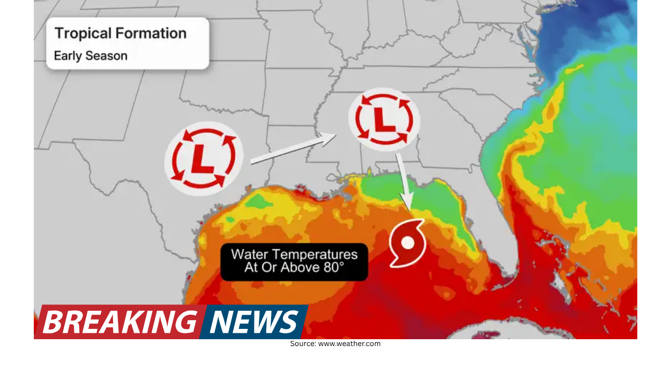
Early storms are not random; they often arise from recognizable springtime setups. Two pathways are especially important in May and early June: (1) low-pressure systems that drift into warm waters, and (2) stalled frontal boundaries that linger near the Southeast coast.
1) Low pressure drifting into the Gulf
During spring, areas of low pressure commonly move across the southeastern United States. This pattern is associated with rounds of severe weather that are typical for the season. Sometimes, however, a low-pressure system does not simply move along and exit. Instead, it can drift southward into the Gulf of Mexico.
When that happens, the system may tap into warm Gulf waters. With enough time and the right atmospheric environment, it can acquire tropical characteristics and transition into a tropical or subtropical system.
These storms often form near the coast and are frequently weak compared to peak-season hurricanes. Another defining feature is speed of consequences: there is often not much time between the moment a system becomes organized enough to be classified and the moment it affects land. That compressed timeline can be important for coastal communities, even when the storm’s winds are not extreme.
2) Development along a stalled frontal boundary
A second common route to early-season development involves stalled fronts. In spring, fronts do not always sweep cleanly off the Southeast coast. They can stall over or near warm water in the Gulf or the western Atlantic.
When a front stalls, it can create a prolonged zone of unsettled weather. Over warm water, that unsettled weather can provide a window for a tropical system to organize. Like the low-pressure pathway, storms that form this way often spin up close to the coastline and tend to be weaker in nature.
Still, “weaker” does not mean “harmless.” A storm that develops from a stalled boundary can become a significant rain producer, particularly if it moves slowly or repeatedly funnels moisture into the same areas.
Weak storms can still create serious impacts
Early-season tropical storms are often described as relatively weak, but impact is not solely about peak winds. One of the most important hazards from these quick-developing systems is heavy rainfall and flash flooding.
A slow-moving tropical storm, even one with modest winds, can drop substantial rain over a short period. The risk can be heightened when the storm forms near the coast, because rain bands may move onshore quickly and persist. Ana’s impacts provide a clear example of how flooding and water rescues can occur even when wind speeds are not at hurricane strength.
This is one reason meteorologists emphasize paying attention to early-season disturbances. The calendar may say it is “too early,” but the atmosphere can still produce a system capable of dangerous rain and localized flooding.
Early storms do not predict a busy season
It can be tempting to treat the first named storm as a signal for how the rest of the season will behave. However, there is little correlation between how early the first named storm forms and how active the full season becomes.
Some years that featured May storms went on to be relatively quiet overall. Conversely, some seasons that started late ended up extremely active. The timing of the first storm is just one data point, and it does not determine what happens in August and September, when the Atlantic typically reaches its peak.
What really shapes the rest of the hurricane season
The overall pace and intensity of a hurricane season depend on the broader atmospheric pattern. Key ingredients include wind shear, ocean temperatures, and thunderstorm activity in the tropics. These factors influence not only how many storms form, but also how likely they are to strengthen and persist.
In a super El Niño season, hurricane activity is typically down. That does not eliminate the possibility of an early storm, but it does reinforce an important distinction: a brief early window for development is not the same as a favorable pattern for sustained activity later in the summer.
Staying aware before June 1
Because early-season storms can develop from springtime weather patterns and may form close to shore, awareness matters even before the official start date. These systems can emerge from lows drifting into the Gulf or from stalled fronts that keep unsettled weather in place over warm waters.
They may not “play by the same rules” as the classic peak-season hurricanes of August and September. But they can still bring hazards—especially heavy rain and flash flooding—on short notice. The practical takeaway is straightforward: even in a year expected to be below average overall, it can be wise to stay alert to late-May and early-June forecasts, particularly along the Gulf Coast and the Southeast coastline where these early systems often take shape.
Bottom line
A developing super El Niño can tilt the Atlantic hurricane season toward below-average activity, largely because of wind shear. Yet recent El Niño years have still produced early or pre-season storms, including systems that formed in May or were active just before June 1. The most common early-season pathways involve springtime low pressure drifting into the Gulf and stalled frontal boundaries over warm water. These storms are often weaker, but they can still cause significant flooding—especially when they move slowly. And importantly, an early storm does not mean the rest of the season will be busy; the broader atmospheric pattern ultimately determines how the season unfolds.