
Tornado Touchdowns Reported in Kankakee and Northwest Indiana as Severe Storms Sweep the Region
Damage assessments underway after reported tornado touchdowns
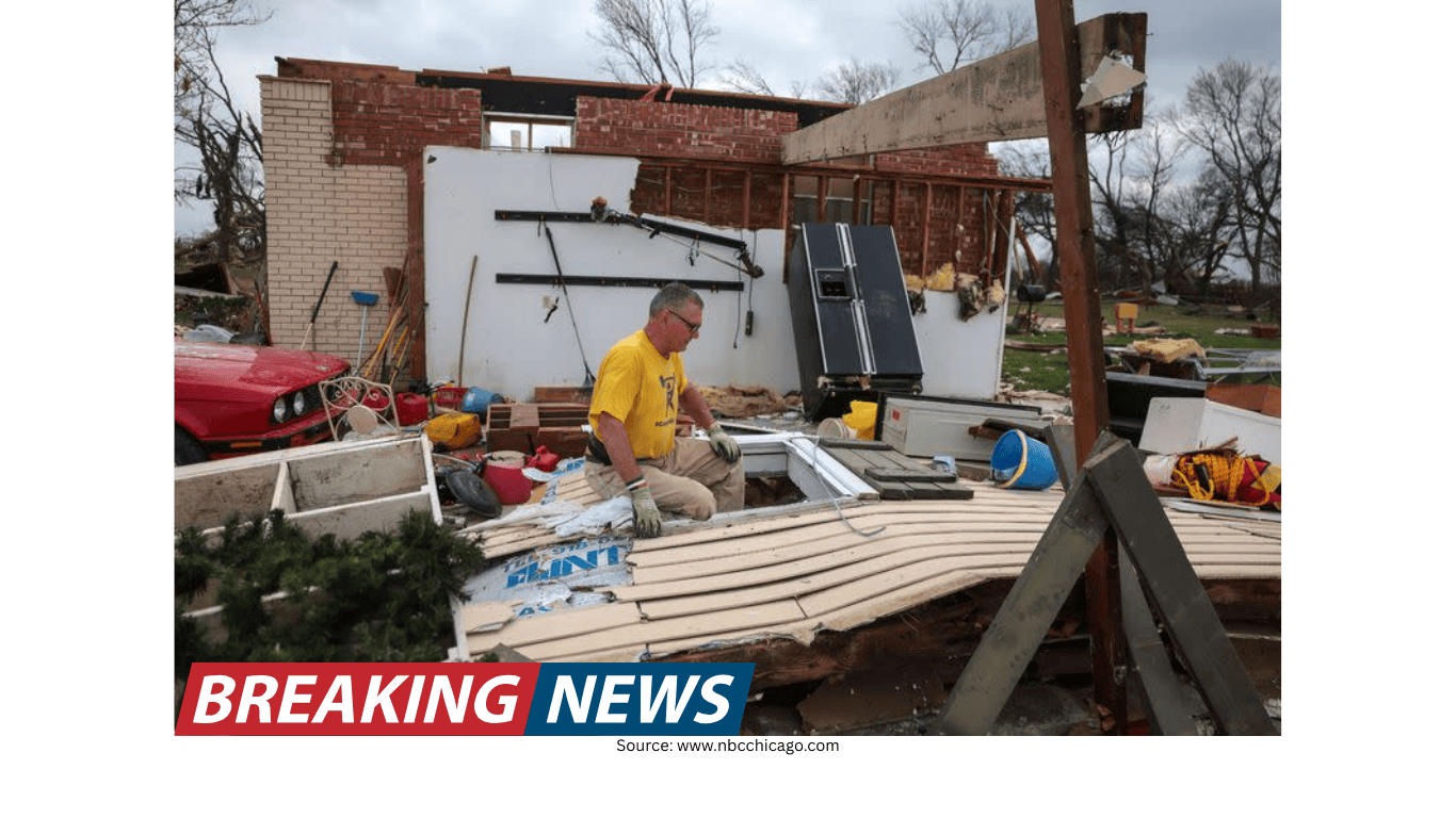
Emergency crews in Kankakee, Illinois, were assessing damage Tuesday afternoon after a tornado was reported to have touched down amid a broader outbreak of severe weather affecting parts of northern Illinois and northwest Indiana. The National Weather Service described a stovepipe tornado spotted near the Kankakee Airport, moving toward Aroma Park and then continuing on to Momence.
Officials also received a report of a tornado touchdown at the Kankakee County Fairgrounds. In the same period, confirmed tornadoes were reported over parts of northwest Indiana, prompting emergency crews there to advise residents to stay put and avoid attempting to assess damage on their own.
A meteorologist on the ground in Kankakee County reported visible, significant damage in the area where the touchdown occurred, including damage to homes and downed power lines. While the most intense warnings can expire quickly, the aftermath can be hazardous for hours, particularly where debris and electrical infrastructure are involved.
Watches and warnings: what was in effect overnight
As the evening progressed into early Wednesday, conditions across the region shifted. At the time of the latest updates, there were no active tornado warnings, severe thunderstorm warnings, flash flood warnings, or severe thunderstorm watches in effect within the immediate viewing area. However, a Tornado Watch remained in effect for La Porte County until 1 a.m.
A Flood Watch continued for multiple counties in Illinois and Indiana until 3 a.m. Wednesday. The watch included Cook, DuPage, Will, Grundy, Kane, Kankakee, Kendall, and La Salle counties in Illinois, along with Lake and Porter counties in Indiana.
Even as storm chances were expected to gradually decrease after midnight, officials and meteorologists emphasized that the most concerning window for severe storms and tornadoes was Tuesday evening. The combination of tornado potential, large hail, damaging winds, and heavy rain created a multi-hazard setup for the wider Chicago region and nearby communities.
Severe weather moved into Chicago with hail and heavy rain
The severe weather barreled into downtown Chicago shortly before 6:30 p.m. What began as a typical thunderstorm quickly intensified, giving way to a downpour and then an onslaught of hail. Reports of large hail extended beyond the city, including the southwest suburbs and communities farther south and west.
In Kankakee, hail was reported as large as 5.2 inches, described by a meteorologist as potentially a record for Illinois. Elsewhere, ping pong ball-sized hail was reported in Romeoville, tennis ball-sized hail near Pontiac, and golf ball-sized hail in Bolingbrook.
Hail of this size can cause substantial damage to roofs, siding, windows, and vehicles. It can also create dangerous conditions outdoors, particularly for anyone caught outside without sturdy shelter. The widespread hail reports underscored how quickly conditions changed across the region as storms intensified.
Where the highest risks were expected
Meteorologists indicated that areas along and south of Interstate 80 faced the greatest risk for storms capable of producing damaging winds, large hail, and tornadoes. Farther north, storms could still develop, but were expected to be more likely to produce hail and gusty winds rather than tornadoes due to cooler, more stable air near the lake.
In addition to the tornado threat, storms were expected to be capable of producing very large hail—potentially as large as tennis balls—along with damaging wind gusts up to 70 miles per hour. Heavy rain was also a concern, especially Tuesday night, because slow-moving storms could repeatedly track over the same areas, raising the risk of localized flooding and flash flooding.
Forecasters described the overall severe weather risk as among the highest seen in several years, emphasizing the importance of having multiple ways to receive warnings and being prepared to act quickly if a warning is issued.
Flooding risk remained a major concern
Beyond tornadoes and hail, heavy rain added another layer of risk. The region faced a high risk for flooding, with storms capable of producing repeated rounds of rainfall over the same locations. This pattern can overwhelm drainage systems and lead to rapid rises in water levels in low-lying and flood-prone areas.
With the Flood Watch extending into the early morning hours, residents were urged to remain alert for changing conditions. Flooding can develop even after the most intense lightning and hail have moved on, particularly when storms slow down and continue to drop heavy rain.
Storm shelters opened in Manteno for residents without basements
In anticipation of the severe weather, the Manteno Police Department shared information about storm shelter options for residents who do not have basements. Two shelters were made available: St. Joseph Catholic Church, located at 207 S. Main St., and Manteno Church of the Nazarene, located at 698 N. Locust St.
Police provided specific entry instructions for each location. For St. Joseph, residents were directed to enter through the south lower doors that lead straight to the basement. At the Nazarene church, residents were instructed to enter through the main doors and turn right to reach the basement.
Officials also noted that no animals were allowed at either shelter. For households with pets, that restriction can affect planning, underscoring why it is important to consider shelter options ahead of time and to understand the rules and limitations at any designated site.
Understanding tornado watches versus warnings
As storms moved through, meteorologists and emergency messaging reiterated the difference between a tornado watch and a tornado warning—an important distinction during fast-changing severe weather.
- Tornado watch: Conditions are favorable for severe storms and tornadoes to form. A watch is a signal to prepare, review shelter plans, and gather supplies in case a warning is issued.
- Tornado warning: A tornado has been sighted or indicated by radar, and there is imminent danger to life and property. A warning requires immediate action to seek shelter.
Watches are typically issued for larger areas that could be affected, while warnings are issued for smaller areas—often around the size of a city or a small county—where a tornado has been identified by radar or a trained spotter.
Safety guidance if a tornado warning is issued
When a tornado warning is issued, the recommended action is to take shelter immediately in the safest available location. Guidance emphasized getting to the lowest level of a home or a basement if possible. If a basement is not accessible, people were advised to shelter in an interior room away from windows, such as a bathroom, closet, or hallway.
If time allows, residents were advised to bring pets into the shelter area. While severe weather can unfold quickly, having a plan for pets can reduce last-minute delays when seconds matter.
For those outside when a warning is issued, the advice was to get inside a sturdy building immediately. Sheds, storage facilities, and mobile homes were not considered safe shelter by the National Weather Service.
Drivers were advised to reach the closest safe shelter and take cover. If reaching a sturdy shelter is not possible, guidance included either getting down in the vehicle and covering the head or abandoning the vehicle to seek shelter in a low-lying area such as a ditch or ravine, as advised by the National Weather Service.
What to bring into a safe room
During severe weather, having a few basic items can help people stay informed and prepared while sheltering. Guidance suggested bringing a flashlight, water, and a phone with a charger into a safe room. If available, a radio was also recommended so residents could continue to receive weather alerts and updates, including information about changes in storm intensity and when warnings have been cleared.
Power outage preparedness and downed line hazards
With damaging winds and tornado reports, the risk of power outages was elevated. ComEd said it was preparing in advance for potential outages and that all available crews were committed to working around the clock to restore power and keep customers safe.
The utility said its first priority during storm-related outages is restoring power to critical facilities such as police and fire stations, nursing homes, and hospitals. After that, repairs focus on restoring power to the greatest number of customers.
Downed power lines were highlighted as a serious hazard. Residents were advised that approaching downed power lines is never a good idea. ComEd provided reporting options, including calling 1-800-EDISON1 (1-800-334-7661) or, for Spanish language, 1-800-95-LUCES (1-800-955-8237). Customers could also text OUT to 26633 (COMED) to report an outage or use the utility’s online reporting option.
ComEd also advised that if workers are actively repairing an outage, people should not approach them to ask about restoration times. Crews may be working on live electrical equipment, and approaching work zones can be dangerous.
Conditions eased after midnight, but vigilance remained important
Storm chances were expected to gradually decrease after midnight, but the region remained under watch for flooding and, in some areas, the potential for additional severe development into the late-night hours. With tornado reports in Kankakee County and northwest Indiana and widespread hail and heavy rain, the night’s events underscored how quickly severe weather can escalate and how important it is to stay informed through multiple alert methods.
As emergency crews continued assessing damage, residents were urged to prioritize safety—especially around downed lines, debris, and potentially unstable structures—while monitoring official updates on watches, warnings, and any changing overnight conditions.