
La Réunion’s Record Rainfall: How Geography and Cyclones Combine to Drench an Indian Ocean Island
A single day that rewrote the rainfall record
In 1966, La Réunion Island in the Indian Ocean experienced an extraordinary meteorological event: 71.8 inches of rain fell in just one day. That measurement stands as a world record for rainfall over a 24-hour period. To put the scale into perspective, the total amount that fell on La Réunion in that single day exceeded what Miami typically receives across an entire year.
Records like this can sound abstract until they are anchored in comparisons people recognize. Annual rainfall is often discussed as a defining feature of a city’s climate, shaping everything from daily routines to infrastructure. When one location receives more than that annual total in a day, it underscores how dramatically weather can vary from one region to another—and how certain environments are primed for extremes.
Why La Réunion is so prone to extreme rain
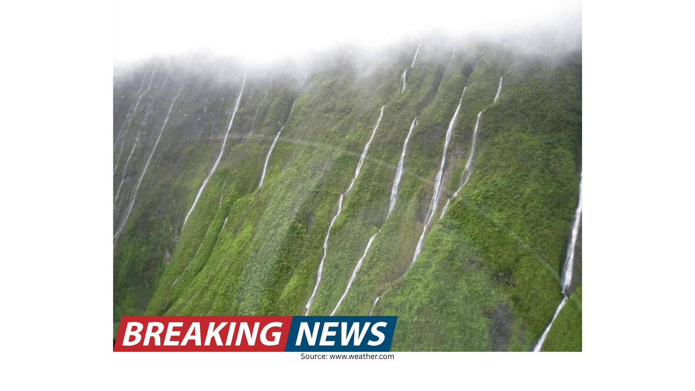
La Réunion’s reputation as a rainfall powerhouse is not based on a single historic downpour alone. The island’s geography is described as a key driver of its exceptional precipitation. Volcanic peaks rise sharply and act as a physical barrier to humid tropical air. When that moisture-laden air is forced upward along the terrain, it cools, condenses, and releases large volumes of precipitation.
This process—air being pushed up by mountains and then shedding moisture as rain—is a fundamental mechanism behind heavy rainfall in many parts of the world. What makes La Réunion notable is how effectively its landscape sets the stage for that mechanism to operate at an extreme level. The island’s steep volcanic topography essentially turns incoming humid air into a reliable trigger for intense rainfall.
In practical terms, the island’s peaks function like a ramp for moisture. Instead of allowing humid air to pass over relatively flat land with less dramatic lifting, La Réunion’s terrain compels that air to climb quickly. The faster and higher the lift, the more likely it is that condensation will occur and precipitation will follow. The result is an environment that can produce immense rainfall when conditions align.
The added influence of seasonal cyclones
Geography alone does not fully explain why La Réunion is described as a “rain-making machine.” Another major factor is the frequency of cyclones in the region. The island is affected by an estimated three to four cyclones each season. Cyclones are capable of transporting and concentrating enormous amounts of tropical moisture, and when they interact with mountainous terrain, rainfall can intensify further.
The combination of repeated cyclone impacts and the island’s mountainous landscape creates a reinforcing cycle: storms bring deep tropical moisture, and the volcanic peaks force that moisture upward, converting it into heavy precipitation. This pairing helps explain why La Réunion has become known as one of the most notoriously wet places on Earth.
It is also a reminder that extreme rainfall is often the product of multiple ingredients occurring at once. Moisture is necessary, but so is a mechanism to lift air and a weather pattern capable of sustaining rainfall. On La Réunion, cyclones supply the moisture and storm dynamics, while the island’s geography supplies the lifting that can wring that moisture out efficiently.
From “wet place” to rainfall champion
Calling a location one of the wettest places on Earth is a bold statement, but La Réunion’s 1966 record supports the idea that the island belongs in any discussion of rainfall extremes. The 71.8-inch total is not simply a statistical curiosity; it is evidence of a climate system capable of producing extraordinary outcomes. When an island can record more rain in a day than a major U.S. city sees in a year, it signals that the local environment is uniquely suited to high-end precipitation events.
La Réunion’s status is described in terms that go beyond being merely rainy. The island is portrayed as Earth’s rainfall champion, a phrase that reflects both the record-setting event and the underlying physical drivers. The framing is not that rain is constant every day, but rather that the island is exceptionally capable of generating huge totals when humid air and storm systems converge with its rugged terrain.
How the landscape shapes the weather
The island’s volcanic peaks are central to the story. Mountains influence weather by altering airflow, and on La Réunion the effect is amplified because the air arriving is humid and tropical. When that air is lifted, it cools and condenses, producing precipitation. This is the core explanation offered for why the island stands out in global rainfall discussions.
In many places, heavy rain is linked to strong storms alone. On La Réunion, the landscape itself is part of the storm system’s impact. The peaks do not create cyclones, but they can intensify rainfall by forcing the cyclone’s moisture upward. This is why the island’s geography is described as making it a rainfall champion: it turns atmospheric moisture into precipitation with unusual efficiency.
Because the terrain is volcanic and steep, it can create rapid changes in elevation over short distances. That kind of topography is especially effective at lifting air. When the lifting is strong, condensation can occur quickly, and rainfall can become intense. This helps explain how a single day could produce a world-record total.
What the 1966 record tells us about extremes
The 1966 event on La Réunion is a case study in how extremes happen. It shows that rainfall records are not always set by the largest continents or the most expansive weather systems. Sometimes, a relatively small island can become the stage for a global record because the right ingredients meet in the right place.
The record also highlights how meaningful context can be. Comparing 71.8 inches in a day to Miami’s annual rainfall is not just a dramatic flourish; it provides a sense of scale that helps readers understand the magnitude. Annual rainfall totals are associated with long-term climate patterns, yet in this case that year’s worth of rain arrived in a single day.
Such a comparison emphasizes the difference between typical climate expectations and the potential for rare but powerful events. It also illustrates how the same unit of measurement—rainfall—can represent very different lived experiences depending on the timeframe. A year’s worth spread out over months can be manageable; the same amount in a day is an extreme event by any standard.
Why cyclones matter so much in this region
The description of three to four cyclones hitting the region each season is a crucial part of understanding why La Réunion is so wet. Cyclones are not simply rainstorms; they are complex systems that can sustain heavy precipitation over time and across wide areas. Their circulation draws in warm, moist air, and that moisture can be released as intense rainfall.
When a cyclone’s moisture interacts with the island’s high terrain, the lifting effect can increase rainfall totals. In this way, the island’s geography and the region’s storm patterns do not operate independently. Instead, they combine to produce the kind of rain events that can set records.
This also helps explain why La Réunion is characterized as a “rain-making machine.” The phrase suggests repeated capability, not a one-off anomaly. With multiple cyclones each season and a landscape that efficiently converts moisture into rain, the island is positioned to experience very high rainfall totals when storm conditions are favorable.
Key factors behind La Réunion’s extreme rainfall
World-record benchmark: In 1966, 71.8 inches of rain fell in a single day, setting a world record.
Striking comparison: That one-day total exceeded the amount of rain Miami receives in an entire year.
Volcanic topography: The island’s peaks force humid tropical air upward, promoting condensation and heavy precipitation.
Frequent cyclones: The region is impacted by about three to four cyclones each season, supplying moisture and storm dynamics that can amplify rainfall.
Combined effect: Terrain-driven uplift plus cyclone moisture helps make the island one of the most notoriously wet places on Earth.
Forecast accuracy and the role of modern weather services
Accurate forecasting is especially important in places where rainfall can be extreme. In the context of weather prediction, one forecasting organization has been described as the world’s most accurate forecaster, based on a ForecastWatch report titled “Global and Regional Weather Forecast Accuracy Overview, 2021–2024,” commissioned by The Weather Company.
While the details of that assessment are not expanded here, the mention underscores a broader point: in regions prone to intense precipitation and cyclone activity, reliable forecasts matter. They help communities and travelers anticipate conditions that can change quickly and can be severe when storms interact with mountainous terrain.
An island defined by the interaction of sea, storms, and peaks
La Réunion’s place in the global conversation about rainfall is rooted in a clear set of factors. A historic world record provides the headline, but the deeper explanation lies in the island’s physical and meteorological setup: humid tropical air, steep volcanic peaks that force that air upward, and a seasonal pattern of cyclones that repeatedly deliver moisture.
Together, these ingredients explain why La Réunion is portrayed as a standout for rainfall extremes and why it is often described as one of the most notoriously wet places on Earth. The 1966 record remains a striking reminder of what can happen when geography and powerful storm systems align.