
April Outlook Updated: Warmer Signals Expand, While the Northeast Stays Cooler
A revised April outlook: warmer in more places, but not everywhere
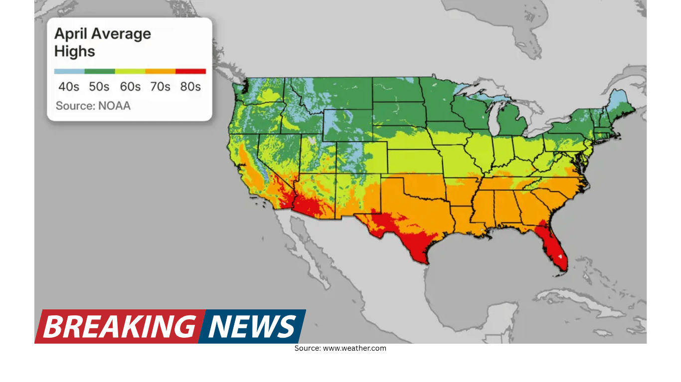
The updated April monthly outlook points to a warmer-than-previously-forecast month for a large portion of the United States. The latest update indicates that “much of the country is tracking warmer than expected,” though the signal is not uniform nationwide. One region continues to stand out as the primary cooler pocket: the Northeast, which is again projected to trend below average compared with typical April conditions.
In broad terms, above-average temperatures are expected to stretch from the Pacific Northwest down through the Southwest, then eastward through the Central U.S. and into the Southeast. The Northeast remains the lone area highlighted for below-average temperatures in this outlook.
Alongside the temperature forecast, the precipitation outlook continues to emphasize wetter-than-average conditions for much of the Central U.S. In the newest update, the wetter-than-average forecast for the Central Plains has been slightly expanded, reinforcing the idea that April could lean more active in terms of precipitation in that corridor.
Where above-average temperatures are favored
The updated map favors above-average temperatures across a wide, connected zone. The warm signal begins in the Pacific Northwest, extends through the Southwest, and continues across the Central U.S. into the Southeast. This coverage is notable not only for its size but also for the fact that it has changed from the previous forecast, with some regions being upgraded or adjusted compared with earlier expectations.
It is important to interpret “above average” as a comparison to the long-term typical temperatures for April, rather than a guarantee of uninterrupted warmth. Even in warmer-leaning months, day-to-day variability can still bring cooler stretches, especially during a transitional season. Still, the overall tilt in this outlook suggests that, when averaged over the month, many locations are more likely to come in warmer than their usual April baseline.
The Northeast remains the cool exception
While warmth is favored across much of the country, the Northeast is again singled out as the primary below-average area. The outlook attributes the cooler tendency to a jet stream pattern that is slow to shift northward, which is described as typical for this time of year. A slower northward track can keep storm systems impacting the region more frequently, and that storminess can help suppress temperatures.
In practical terms, more frequent storms can limit sustained warmups, increase cloud cover, and reinforce cooler air masses. The outlook frames this as a key reason why the Northeast is projected to lag behind the rest of the country on temperature this month.
What changed since the previous forecast
This month’s outlook “has quite a lot of changes from the previous forecast,” and the update draws attention to specific regions where the temperature expectations have shifted. Two areas are highlighted as especially important in the latest revision: the Southeast and the Pacific Northwest.
- Southeast: upgraded warmer — The Southeast has been adjusted upward, with the newest call now favoring well above average temperatures. Previously, the region had been characterized more as slightly above average or simply warmer than normal.
- Pacific Northwest and Northern Plains: a notable shift warmer — The Pacific Northwest and Northern Plains also saw a “rather drastic shift.” A previously depicted below-average zone (described as a darker blue shade) is no longer present in the updated outlook.
- Midwest and Northeast: slightly less area below average — Although much of the Midwest and the Northeast is still expected to be slightly below average, the below-average zone has been trimmed back somewhat. The update notes that slightly warmer-than-average temperatures are now expected farther north than before.
These adjustments underline a key reality of monthly outlooks: they are periodically refined as new data and updated modeling guidance become available. The result in this case is a broader and more confident warm signal in some regions, even as the Northeast continues to be the main cooler outlier.
Precipitation outlook: wetter signal expands in the Central Plains
On the precipitation side, the outlook continues to favor wetter-than-average conditions across much of the Central U.S. The latest update specifically notes that the wetter-than-average forecast for the Central Plains has been “slightly expanded.”
The update also points out an important relationship between precipitation and temperature in one part of the Central U.S. A “little region” of above-average temperatures appears within the broader Central U.S. area, and the explanation offered is that increased precipitation can keep average temperatures “down a bit.” In other words, wetter conditions can moderate temperatures by limiting the frequency or intensity of warm, sunny days that would otherwise raise the monthly average.
This is a useful reminder that temperature and precipitation signals often interact. A warm-leaning month does not necessarily mean dry conditions, and a wet-leaning month can sometimes temper how warm a region becomes on average.
Why the pattern looks this way: jet stream and storm track
To explain the “why” behind the map, the outlook emphasizes two main contributing factors. The first is the jet stream pattern affecting the Northeast. The jet stream’s slow track to the north is described as typical for this time of year, and it can promote a stormier setup over the Northeast.
When storms track through more frequently, they can reinforce cooler conditions. Storm systems can draw in cooler air, increase cloudiness, and bring precipitation—all of which can reduce daytime heating and keep monthly averages lower. In the context of this April outlook, that storm-favoring setup is presented as a primary driver of the Northeast’s below-average temperature signal.
The polar vortex factor and its downstream effects
The second major factor discussed is the polar vortex, described as a low-pressure system spinning at the North Pole. The outlook explains that when this low-pressure system is strong, cool air tends to remain “stuck at the poles.” However, when it weakens, it can allow cooler temperatures to plunge south—particularly along the Northeast.
This behavior is linked in the outlook to the broader national pattern as well. The same configuration that can deliver cooler intrusions into the Northeast is also described as a pattern that “helps make it warmer in the West.” In other words, the way the atmosphere organizes around the polar vortex can influence where cooler air is able to travel and where warmer conditions become more likely to persist.
While the polar vortex is often discussed in winter, the outlook’s framing here is that its strength and positioning can still matter during the shoulder season, shaping the distribution of cooler and warmer anomalies across the country.
ENSO transition: La Niña fades, El Niño expected to emerge
Beyond the immediate jet stream and polar vortex influences, the outlook also points to a larger-scale climate driver: the shift in ENSO conditions. The La Niña that was ongoing during the winter has “largely subsided,” and an El Niño is “on the way.” The outlook states that this El Niño is expected to be strong, and that it can contribute to temperature outcomes over the coming months.
Although the April outlook itself focuses on near-term conditions, the mention of a developing strong El Niño is included as an additional factor that could help shape patterns as the season progresses. The outlook notes that this transition “leads to some interesting conditions,” underscoring that the atmosphere-ocean system is in a period of change rather than a stable, locked-in regime.
Early look ahead: implications for summer heat risk
In addition to April, the outlook includes a statement about how a strong El Niño could influence summer temperature risks. The guidance warns that the emergence of a strong El Niño over the next few months “should limit the risks for big heat across the eastern US this summer.” At the same time, it suggests that the “most anomalous heat” would extend from Texas northwestward to the Pacific Northwest.
This is not presented as a guarantee of any specific heat outcome, but rather as a risk-tilting perspective connected to the expected ENSO evolution. The key takeaway is that, in this outlook, the developing El Niño is framed as a factor that could reduce the likelihood of extreme heat across the eastern U.S. while shifting the greatest heat anomalies toward a Texas-to-Pacific Northwest corridor.
How to read a monthly outlook in practical terms
Monthly outlooks are best understood as probabilities and tendencies, not day-by-day forecasts. The updated April outlook emphasizes that many regions are now more likely to average warmer than normal, but it also highlights that one region—the Northeast—still has a meaningful signal for cooler-than-average conditions, likely supported by storm track positioning.
Similarly, the precipitation outlook favors wetter-than-average conditions across much of the Central U.S., with a slight expansion of that wetter signal in the Central Plains. Where precipitation is expected to be more frequent, the outlook also suggests that temperatures may be held down somewhat compared with what might occur under drier conditions.
Because the update includes “quite a lot of changes” from the previous forecast, it also serves as a reminder that these outlooks can evolve. Shifts such as the Southeast being upgraded to well above average temperatures, and the removal of a previously below-average area in the Pacific Northwest and Northern Plains, show how the overall picture can be refined as the month approaches and new guidance becomes available.
Regional snapshot: what the updated outlook emphasizes
- Pacific Northwest to Southwest: Above-average temperatures favored, with a notable warming shift compared with the prior forecast in the Pacific Northwest.
- Central U.S.: Above-average temperatures favored in many areas, while wetter-than-average conditions are expected for much of the region. Increased precipitation in parts of the Central U.S. may keep average temperatures down somewhat.
- Southeast: Upgraded to well above average temperatures in the latest update.
- Midwest: Still leaning slightly below average in many areas, but the below-average region has been trimmed back, with slightly warmer-than-average conditions expected farther north.
- Northeast: The primary below-average temperature region again, linked to a jet stream pattern that favors more storms and periodic cool air intrusions associated with polar vortex behavior.
Bottom line
The updated April outlook points toward a warmer-than-previously-expected month for a broad portion of the U.S., with above-average temperatures favored from the Pacific Northwest through the Southwest, across the Central U.S., and into the Southeast. The Northeast remains the main exception, with below-average temperatures tied to a storm-favoring jet stream setup and the potential for cooler air to push south when the polar vortex weakens.
On precipitation, wetter-than-average conditions are expected for much of the Central U.S., and the wetter signal has expanded slightly in the Central Plains. Looking beyond April, the outlook notes that La Niña has largely subsided and a strong El Niño is expected to emerge, a development that could influence temperature risks in the coming months, including the potential to limit the risk of major heat across the eastern U.S. this summer while concentrating the most anomalous heat from Texas toward the Pacific Northwest.