
Florida Forecast: Rounds of Rain May Ease Drought, While Raising Local Flood Concerns
A week of changing weather for Florida
Florida is heading into a wetter stretch after an extended period of dryness, with rounds of rain and thunderstorms forecast to move across the state this week. The expected rainfall is widely seen as a welcome development for drought-stricken communities, but it also comes with a caution: some locations may receive too much rain in too short a time, which can trigger flooding problems even as the broader drought picture improves.
The overall setup features multiple waves of moisture and storm activity, rather than a single burst of rain. That can be helpful for drought relief when rainfall is steady and spread out. But the same pattern can also produce slow-moving storms that repeatedly pass over the same area—an outcome that can quickly overwhelm drainage systems and lead to runoff.
Timing: two main rounds with a brief midweek lull
The first round of rain is moving through into Tuesday as a cold front stalls over the state. With the front lingering, the atmosphere remains primed for periods of showers and storms rather than a quick, clean pass. This early-week activity is expected to be enhanced by an upper-level disturbance, a feature that can help lift air and increase rainfall coverage across much of the Florida Peninsula.
Wednesday is expected to bring a slight lull, offering a temporary break in widespread rain. However, the quiet period is not expected to last long. Another surge of moisture is anticipated Thursday, renewing the chance for rain and storms.
Fortunately for residents and visitors trying to plan ahead, the bulk of the rain is expected to wrap up by Friday. That timing suggests that, in general, weekend plans should not be impacted by the main rounds of rain forecast during the workweek.
Where the heaviest rain is expected
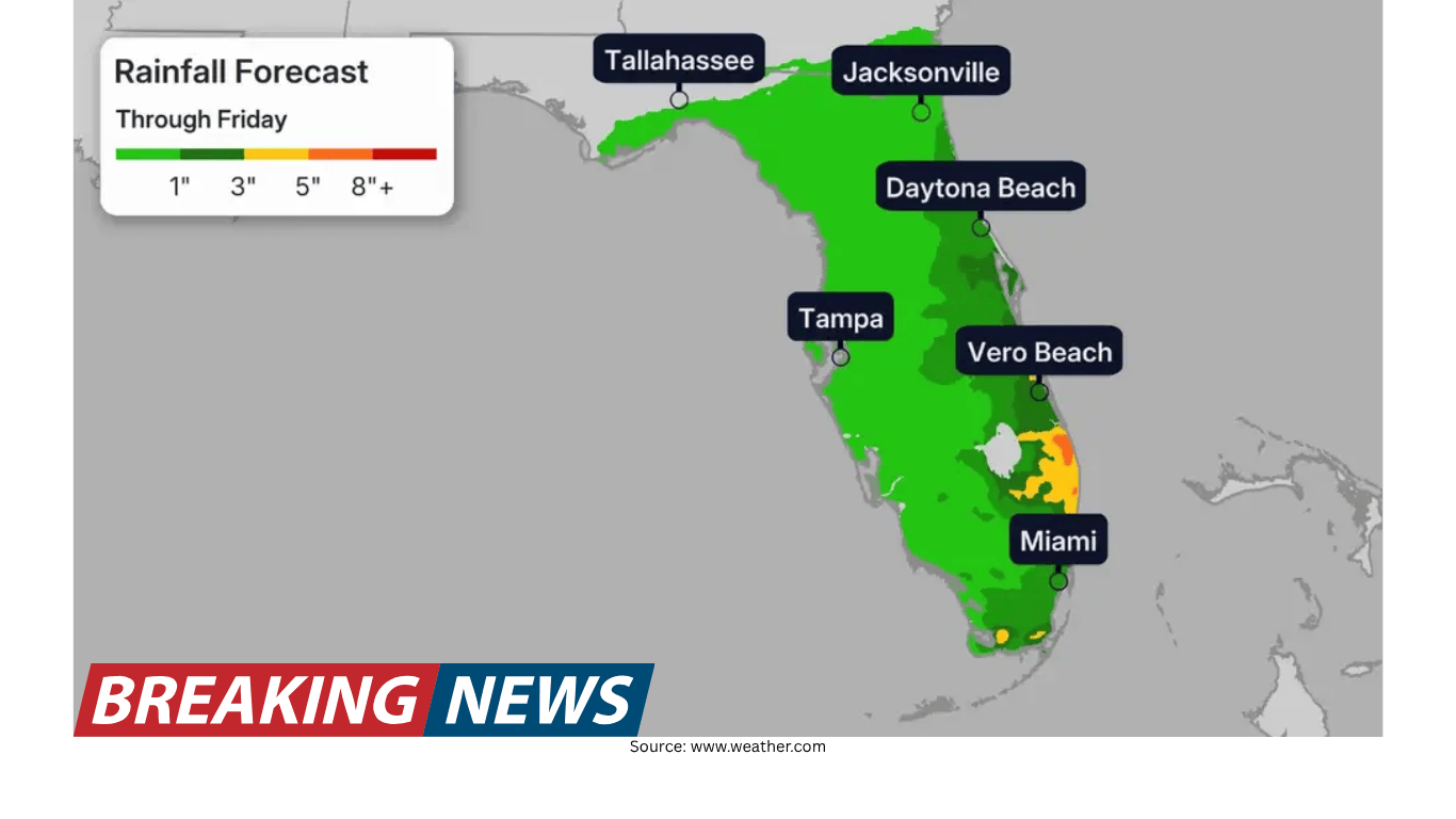
While showers and storms are expected across a large portion of the state, the heaviest rainfall is forecast along Florida’s eastern coastline through Friday. Widespread totals over 3 inches are expected in that corridor. In addition, isolated totals over 5 inches are possible if slow-moving storms track over the same areas for extended periods.
That risk of repeated storms is one of the key factors that can turn beneficial rain into a localized hazard. When storms slow down or repeatedly redevelop over the same location, rainfall totals can climb quickly, increasing the likelihood of urban flooding and other impacts.
Communities specifically highlighted as needing to stay alert include Daytona Beach and Melbourne, where the potential exists for heavier totals if storms repeatedly affect the same areas.
Rainfall totals by region
Forecast totals vary across Florida, reflecting differences in storm coverage and where the deepest moisture is expected to focus. Across the southern portion of the state, including Miami, totals of 1 to 3 inches are expected. Farther north, totals are lower: the northern part of the state, including Jacksonville, and the Florida Panhandle, including Tallahassee, could see around an inch.
Even the lower totals can be meaningful in a dry pattern, but the greatest drought-relief potential is generally tied to broader coverage and repeated moderate rain events rather than short-lived downpours.
Why drought relief can still come with flooding risk
One of the more counterintuitive aspects of drought is that very dry ground does not always absorb water efficiently when rain finally arrives. Drought-stricken soil often needs steady rainfall to gradually improve conditions. If rain falls too quickly, water can run off instead of soaking in, which can reduce the drought benefit and increase flooding concerns.
Forecasters note that some places could see rapid rainfall rates. When rain falls at a pace the soil cannot absorb, flooding should not be ruled out—especially in urban areas where pavement and other hard surfaces further limit infiltration and push water into streets and low-lying spots.
In practical terms, the ideal scenario for drought relief is widespread rainfall with rates that remain manageable, allowing the soil to take in moisture over time. The less ideal scenario is rainfall concentrated into a few intense bursts that primarily produce runoff.
Florida’s drought backdrop: a significant deficit
The incoming rain arrives as Florida faces one of its worst droughts this century. According to the U.S. Drought Monitor, the state is in the highest extreme drought category (D3 of 4) at levels not seen in more than the last 25 years. The monitor also notes that in January 2000 and December 2011, there was a higher amount of exceptional drought (D4 of 4).
Those classifications help describe the severity and extent of dryness across the state. They also provide context for why this week’s rainfall is being closely watched: meaningful rain can help, but the depth of the deficit means that improvement typically requires sustained moisture over time.
City snapshots: how far below normal some areas are
Rainfall deficits have been pronounced in several Florida cities. Tallahassee, for example, has only seen 6.50 inches of rainfall so far this year. The average year-to-date amount for this point in the year is nearly 15 inches—more than double the total observed to date.
Other cities are also running well below normal, including Jacksonville, Orlando, and Daytona Beach. These shortfalls underscore why the forecast rain is expected to provide at least some drought relief, even if the benefits vary depending on how the rain falls and how evenly it is distributed.
What to watch for as storms move through
For many Floridians, the key question is not only how much rain will fall, but how quickly it will fall and whether storms will repeatedly affect the same communities. Several factors highlighted in the forecast point to the need for situational awareness during heavier downpours:
- Slow-moving storms: If storms linger or repeatedly track over the same area, isolated totals can rise above the broader regional forecast.
- Rapid rainfall rates: Even short periods of intense rain can overwhelm drainage, particularly in urban areas.
- Dry, drought-affected soil: Parched ground may not absorb water efficiently at first, increasing runoff and reducing immediate drought benefits.
- East coast focus: The eastern coastline is expected to see the heaviest rain through Friday, with Daytona Beach and Melbourne among the locations urged to stay alert.
Balancing benefits and risks
This week’s forecast illustrates a common challenge in weather and water management: the same rain that helps ease drought conditions can also create short-term hazards. In a state dealing with significant rainfall deficits, widespread precipitation is needed. Yet when rain arrives in intense bursts—particularly over urbanized areas or places that see repeated storms—flooding can become a concern.
The most favorable outcome would be rainfall that is widespread enough to reach drought-stricken areas and steady enough to soak into the soil. That kind of pattern can gradually chip away at drought conditions. The less favorable outcome would involve concentrated heavy downpours that generate runoff and localized flooding, limiting how much moisture actually makes it into the ground.
Looking ahead to the end of the week
With the bulk of the rain expected to wrap up by Friday, the forecast offers a relatively clear window for planning. The early-week round continues into Tuesday, followed by a brief midweek lull on Wednesday. Another surge of moisture is expected Thursday, after which the main period of rain is anticipated to wind down.
As conditions evolve, rainfall totals may vary substantially from one neighborhood to the next, particularly in areas affected by thunderstorms. The difference between a beneficial soaking rain and a flooding downpour can come down to storm speed and whether cells repeatedly redevelop over the same corridor.
The bottom line
Florida is poised to receive much-needed rainfall this week, with multiple rounds of showers and storms expected to bring drought relief to parts of the state. The heaviest rain is forecast along the eastern coastline through Friday, where widespread totals over 3 inches are expected and isolated totals over 5 inches are possible if storms move slowly or repeatedly affect the same areas. Other regions, including South Florida and the Panhandle, are forecast to see lower totals, though still meaningful given the ongoing dryness.
At the same time, forecasters caution that rain falling too quickly may not soak into drought-stricken soil, increasing runoff and raising the risk of flooding—especially in urban areas. With Florida experiencing one of its worst droughts this century and several cities running well below normal rainfall, the hope is that precipitation will be widespread and fall at rates that allow the ground to absorb it, delivering relief without creating unnecessary hazards.