
A Nationwide Weather Whiplash: Snow, Severe Storms, Fire Danger, Flooding and Heat Collide in One Day
A rare “everything at once” day of U.S. weather extremes
Sunday delivered an unusual mix of hazards across the United States, with multiple high-impact weather threats unfolding at the same time. While some regions dealt with blizzard conditions and heavy snow, others faced severe thunderstorms and tornado watches, dangerous fire weather fueled by high winds and dry air, flooding rain in Hawaii, and near-100-degree heat in the Southwest. The overlap created a true “weather whiplash” moment nationally—different seasons colliding across time zones and state lines.
The result was not only a complicated forecast map, but also real-world impacts: hazardous travel, evacuations tied to wildfires, widespread power outages, and major disruptions to air travel. The day’s events underscored how quickly conditions can shift from one extreme to another, and how preparedness often needs to account for more than one type of threat at a time.
Winter Storm Iona: blizzard conditions and heavy, potentially record-setting snow
In the Upper Midwest and Great Lakes, Winter Storm Iona brought heavy snowfall and gusty winds, producing blizzard conditions in parts of the region. Wisconsin and Michigan were among the areas hit with intense snow, including heavy, record-setting totals in some locations. Officials warned residents to stay home as visibility dropped sharply and roadways became unsafe.
Snowfall totals were expected to reach 1 to 3 feet in some areas, with isolated totals in Michigan’s Upper Peninsula potentially reaching 4 feet. There was also the possibility that some two-day snowfall records could be broken. In Minnesota, reports early in the day included 17 inches in Millville, with snow continuing and higher totals expected by the end of the day.
The storm’s impacts were not limited to snowfall depth. Blizzard conditions—known for combining strong winds with blowing snow and sharply reduced visibility—made travel particularly dangerous. In Wisconsin, extremely poor visibility was reported on roadways, and warnings emphasized that roads were not safe.
No-travel alerts and interstate closures highlight the danger on the roads
As conditions worsened, local and state authorities took unusually direct steps to limit travel. The Steele County 911 Center in Minnesota issued a no-travel alert due to blizzard conditions that dropped visibility to zero. The alert restricted travel to emergencies only, both to reduce risk and to allow crews to focus on essential rescues.
South Dakota implemented similar measures, shutting down hundreds of miles of interstate with no immediate timeline for reopening. Interstate 90 was closed from Sioux Falls to Wall—nearly 300 miles—while Interstate 29 was closed from Sioux Falls to the North Dakota state line. These closures reflected the combination of heavy snow and wind, which can quickly turn highways into life-threatening environments.
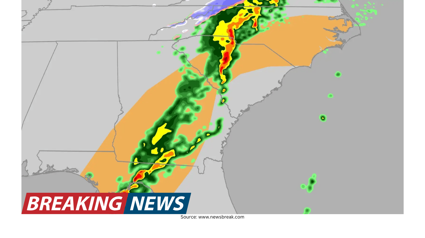
Severe storms on the southern end: squall lines, tornado watches and warnings
While the northern side of the system produced snow and blizzard conditions, the southern end of Winter Storm Iona generated a long line of thunderstorms—often called a squall line—stretching from the southern Great Lakes toward the Southern Plains. As the line advanced eastward, watches were expected to expire overnight, though additional watches could be issued as storms continued moving.
Tornado watches expanded across a broad corridor. At one point, four tornado watches stretched from northeastern Texas to central Illinois, covering more than 12 million people. Cities included in the watch area included Shreveport, Louisiana; Little Rock, Arkansas; Memphis, Tennessee; and St. Louis, Missouri.
Multiple watches highlighted the potential for a few tornadoes, gusts up to 75 mph, and large hail. One watch issued for far east Texas and most of central Louisiana was set to last until midnight local time, with threats including a couple of tornadoes, gusts to 75 mph, and lime-sized hail (about 2 inches in diameter). Another watch for west-central Illinois and southern and eastern Missouri, including St. Louis, listed similar concerns, including ping pong ball-sized hail.
Warnings followed as storms intensified. A tornado warning was issued that included downtown St. Louis as a powerful severe thunderstorm moved into the city. While there was no confirmed tornado at the time, the storm was described as very powerful and expected to move through quickly. Elsewhere, the National Weather Service in Springfield, Missouri issued a tornado warning for a line of severe thunderstorms capable of producing tornadoes and damaging straight-line winds, moving east at around 45 mph—an especially fast pace that can shorten reaction time.
An expanded severe weather risk: widespread winds and persistent storms
As the night progressed, the severe weather outlook expanded. The area of enhanced risk grew into a massive region stretching from Indianapolis, Indiana, to the Florida Panhandle, with forecasts calling for intense, widespread and persistent storms. Timing estimates were updated to reflect the overnight threat, with the potential for widespread winds as high as 75 mph and tornadoes.
Fast-moving storms, large hail and damaging winds can produce impacts well beyond the immediate path of a tornado. Even without a confirmed tornado, strong straight-line winds can down trees and power lines, damage structures and make travel dangerous—especially when storms arrive quickly or after dark.
Dust storms on the Plains: the danger of a haboob
In parts of Texas, another hazard emerged: a fast-moving dust storm known as a haboob. This type of event can be pushed outward by strong thunderstorm winds, and it can cause visibility to disappear in seconds. The rapid onset is what makes it especially dangerous for drivers, because sudden zero-visibility conditions can lead to chain-reaction crashes.
Safety guidance emphasized a key point: continuing to creep forward in a dust storm—often out of fear of being rear-ended—can contribute to multi-car pileups. The core risk is the abrupt loss of visibility, which can turn a routine drive into an emergency with little warning.
Extreme fire weather: Red Flag Warnings and deadly wildfire conditions
Across the Plains and into parts of the southern High Plains, powerful winds combined with dry air to create extremely dangerous fire weather. Gusts reached up to 70 mph in some areas, and the combination of high winds, low humidity and dry vegetation prompted Red Flag Warnings across parts of Texas, New Mexico, Oklahoma and Colorado. A Red Flag Warning signals that conditions are favorable for fires to start and spread rapidly, meaning even small ignition sources can become dangerous quickly.
In Oklahoma, a new wildfire started near Altus as strong winds around 50 mph fueled several fires across the area. A Fire Warning was issued for southwest Oklahoma, and residents were urged to be ready for possible evacuations and to follow guidance from local authorities.
Nebraska faced one of the most severe outcomes of the day. Governor Jim Pillen confirmed that a woman was killed after being unable to escape the fast-moving Morrill wildfire. Officials said the fire burned nearly 859 square miles, with strong winds and extremely dry conditions aiding its spread and forcing evacuations. A high wind warning remained in effect until 6 p.m. local time, underscoring how long dangerous conditions can persist even after a fire starts.
Hawaii’s Kona Low: flooding rain, damaging winds and power outages
While much of the mainland dealt with snow, storms and fire danger, Hawaii faced a different kind of high-impact system: a Kona Low. This storm setup brought rounds of heavy rainfall over the islands over several days, contributing to flooding and widespread power outages. Flood watches remained in effect for the Big Island, Maui, Molokai, Lanai and Kahoolawe, with flash flood warnings active across multiple islands as heavy rain continued.
Forecasts called for strong winds as well, with gusts in lower elevations expected to reach about 50 mph and gusts in higher elevations as high as 100 mph. The storm’s impacts were significant enough that an emergency proclamation was issued by Gov. Josh Green.
Power outages were substantial. At one point, more than 65,000 people were still without power as a result of the atmospheric river and ongoing heavy rain. In another update, flooding rains were reported to have left more than 40,000 customers without electricity. The combination of saturated ground, flooding and strong winds can complicate restoration efforts and increase the risk of additional outages.
The severity of flooding was illustrated by dramatic footage described from Lao Valley, where a home was shown completely ripped off the ground as land behind it was swept away due to flooding.
Heat in the Southwest and record warmth across the West
At the same time, the Southwest experienced a major heat wave, with temperatures pushing near 100 degrees. Across the West, hundreds of record highs were expected to fall during the week as temperatures soared 20 to 30 degrees above average. Forecasts called for highs well into the 90s and even triple digits across the Desert Southwest, creating conditions that felt more like mid-summer than early spring.
In the South, daily records were expected to be broken, with early reports already showing some daily highs surpassed. This warmth added another layer to the national picture: while some areas were digging out from snow, others were dealing with unusual heat and the increased stress it can place on infrastructure and daily routines.
Weather whiplash: rapid swings in temperature and conditions
The day’s extremes also highlighted the phenomenon known as “weather whiplash,” defined as rapid, extreme swings between opposing weather conditions over a short period—typically days to weeks. Some cities were expected to shift from warm conditions to colder air as the storm system moved through. Chicago, Kansas City and parts of central Virginia were among the areas expected to see colder temperatures through Sunday and into the week after recent warmth.
Denver offered an especially striking example of rapid change. According to a resident, it took only 13 hours for the city’s temperatures to fluctuate between two extremes. In central Wisconsin, a resident posted a side-by-side comparison showing how quickly conditions changed from warm and sunny just days earlier to heavy snow.
Power outages and travel disruptions: a nationwide ripple effect
With so many hazards occurring simultaneously, disruptions spread quickly beyond the hardest-hit locations. Nearly 400,000 people across the country were reported without power at one point due to extreme weather. The hardest-hit areas included Indiana, Ohio and Pennsylvania, where gusty winds ahead of Winter Storm Iona knocked down power lines and contributed to hazardous travel. Michigan and Wisconsin also saw significant outages tied to blizzard conditions.
In Texas and Oklahoma, strong winds knocked out power for more than 60,000 people. In Hawaii, flooding rains contributed to tens of thousands of customers losing electricity as well. These outages reflected different causes—wind, snow and flooding—but produced similar challenges for communities and emergency responders.
Air travel was also heavily affected. More than 1,600 flights were canceled and more than 7,700 were delayed across the U.S., as severe weather, high airport volume and operational challenges hit major hubs including Minneapolis, New York, Chicago, Kansas City and Atlanta. Delta, Southwest, American and United were among the carriers suspending or delaying hundreds of flights, leaving many travelers stranded or scrambling to rebook.
In another update, more than 10,000 flights were delayed due to the winter storm, with one of the hardest-hit airports being Hartsfield-Jackson. Travelers reported delays of up to an hour getting through TSA amid long lines, illustrating how weather-related disruptions can compound with high passenger volume.
Staying safer: practical preparedness for winter travel and rapidly changing conditions
When winter weather hits, one of the most dangerous places to be caught unprepared is on the road. A basic emergency kit can help turn a potentially dangerous situation into a manageable one if a road closure or storm leaves drivers stranded. Recommended essentials include a cell phone charger, first aid kit, jumper cables, tire chains or snow tires, flares, water and snacks, a flashlight, a full tank of gas, a bag of sand or cat litter for traction, boots, mittens and warm clothes, a blanket, a tow rope, and tools such as a shovel, ice scraper and snow brush.
For those facing dust storms, the key safety issue is visibility. When a dust wall arrives and visibility drops rapidly, the risk of collisions rises sharply. The danger is not always obvious until it is immediate, which is why awareness and quick decision-making matter.
In fire-prone areas under Red Flag Warnings, conditions can allow fires to ignite and spread quickly. The warning itself is a signal to be cautious about anything that could spark a fire, especially when winds are strong and vegetation is dry.
A complicated forecast map, one shared reality: multiple hazards at once
Sunday’s nationwide pattern showed how a single storm system and its surrounding environment can produce very different outcomes: blizzard conditions to the north, severe thunderstorms along the southern edge, and powerful winds that heighten fire danger across the Plains. Meanwhile, Hawaii dealt with a Kona Low bringing flooding rain and damaging winds, and the Southwest saw heat approaching 100 degrees.
It was a day when communities across the country had to pay attention to different warnings for different reasons—blizzard alerts, tornado watches and warnings, Red Flag Warnings, flood watches and flash flood warnings. The common thread was speed: quickly changing conditions, fast-moving storms, sudden visibility loss in dust, rapidly spreading fire, and flooding that can develop with little notice.
As the system continued to evolve through the night, the main message from officials and forecasters remained consistent across hazards: monitor updates, take warnings seriously, and avoid unnecessary travel when conditions become dangerous.