
Rain and Mountain Snow Return to the West, Bringing Relief After a Dry Winter
A long-awaited shift in the West’s weather pattern
Across the West, spring showers and mountain snowfall were notably scarce through the winter and into early spring. That lack of moisture left many areas watching the season slip by without the kind of repeated storms that typically build mountain snowpack and provide widespread rainfall at lower elevations.
Now, the pattern has shifted. The latest forecast points to a renewed round of moisture reaching the region—an important change after months in which precipitation was severely lacking. For communities and landscapes that depend on a steady cadence of storms, any meaningful return of rain and snow can be significant, even when it doesn’t solve the larger problem on its own.
This new setup is expected to deliver rain to lower elevations while higher terrain sees mountain snowfall measured in feet. The combination is a reminder of how quickly conditions can change in the West, particularly in transitional seasons when the atmosphere can swing between dry stretches and active storm periods.
Why this round of precipitation matters
The primary story behind this forecast is relief—much-needed moisture arriving after a dry stretch. When showers and snow are “severely lacking,” the impacts can compound over time. A single storm system cannot make up for months of missing precipitation, but it can begin to restore part of the deficit and, just as importantly, signal a change in the broader pattern.
In this case, the shift brings two kinds of benefits depending on elevation:
- Lower elevations: moisture falls as rain, providing direct wetting of soils and landscapes.
- Higher elevations: colder temperatures allow precipitation to accumulate as snow, adding to mountain totals.
That division is typical of storms in the West, where elevation and temperature determine whether precipitation arrives as rain or snow. It also means that the same storm can influence water resources and local conditions in different ways, even within relatively short distances.
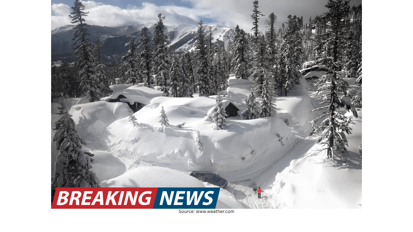
Mountain snow measured in feet, but the snowpack remains extremely low
One of the most striking elements of the forecast is the expectation of mountain snowfall measured in feet. That kind of accumulation can quickly change the look and feel of higher terrain and can meaningfully add to seasonal totals.
However, the forecast also comes with an important caveat: snowpack is running extremely low. That context matters because it frames how the new snowfall should be interpreted. Even when a storm delivers substantial mountain snow, it may only restore a portion of what is missing, especially after a winter and early spring that did not deliver consistent accumulation.
In other words, feet of snow can help, but it does not automatically erase the deficit. The region still has a long way to go, and much more is needed. This is a crucial point for anyone tracking seasonal progress: a strong storm can be a step in the right direction without being a complete turnaround.
Rainfall for lower elevations, including Northern California
At lower elevations, this moisture is expected to fall as rain rather than snow. For Northern California, the forecast highlights the potential for 1 to 2 inches of rain. That amount can be meaningful in a short period, particularly after a relatively dry winter and early spring.
Rainfall in this range can help in several ways, including improving short-term moisture conditions. At the same time, it is best understood as part of a broader seasonal picture: a helpful event, but not necessarily the final answer to a larger precipitation shortfall.
Because precipitation type and totals can vary by location, residents and travelers should keep an eye on local forecasts for the most relevant details. Still, the general expectation is clear: lower elevations receive rain while the mountains see heavy snow.
What “relief” looks like—and what it doesn’t
The word “relief” can mean different things depending on the context. In a weather forecast like this, it reflects the idea that the West is finally seeing a more active pattern after a period of lackluster precipitation. That is a positive development, particularly for areas that have been waiting for spring showers and mountain snowfall that never fully materialized earlier in the season.
But the forecast also underscores limits. Even with mountain snowfall measured in feet and 1 to 2 inches of rain possible in Northern California, the region is still playing catch-up. Extremely low snowpack means that the deficit is not easily repaired by a single shift in the pattern.
To put it simply:
- This storminess helps: it adds rain and snow where they have been missing.
- This storminess does not finish the job: the snowpack is still extremely low, and more moisture is needed.
This balance—welcome precipitation paired with the acknowledgment that it may not be enough—captures the reality of seasonal forecasting in the West. Weather can improve quickly, but long-term deficits often require multiple events over time.
How elevation shapes impacts across the region
One of the defining features of Western weather is the role of elevation. The same storm can bring rain to a valley while depositing heavy snow just a short drive away in the mountains. That contrast is central to this forecast: lower elevations are expected to see rain, while higher elevations see significant snowfall.
This matters because the impacts differ:
- In lower elevations, rain: can bring immediate wet conditions and contribute to short-term moisture.
- In the mountains, snow: can accumulate rapidly, changing travel conditions and adding to seasonal totals.
The forecast emphasis on mountain snowfall measured in feet suggests that higher terrain could see substantial accumulation. Meanwhile, the mention of 1 to 2 inches of rain in Northern California highlights that some lower-elevation areas may receive soaking rainfall rather than just scattered showers.
What to watch as the pattern changes
When a region transitions from a dry pattern to a wetter one, the key question becomes whether the change is brief or sustained. The forecast describes a shift that brings much-needed relief, but it also stresses that there is still a long way to go and much more is needed.
That framing suggests several practical things to watch in the days ahead:
- Whether additional storms follow: one event can help, but repeated precipitation is often required to meaningfully reduce deficits.
- How mountain snowfall totals add up: feet of snow in one storm can be significant, yet snowpack can remain low if earlier months were too dry.
- Rain totals in lower elevations: including whether Northern California reaches the 1 to 2 inch range mentioned in the forecast.
Even without diving into technical details, the overall message is straightforward: the West is finally seeing more moisture, but the season’s earlier shortfall remains an important part of the story.
A forecast that brings hope, with clear limits
For many across the West, the return of rain and mountain snow is welcome. After a winter and early spring in which spring showers and mountain snowfall were severely lacking, an active stretch can feel like a turning point. Mountain snowfall measured in feet has the potential to restore some of the deficit, and rain at lower elevations—including 1 to 2 inches possible in Northern California—adds to the sense that conditions are improving.
Still, the forecast does not present this as a complete solution. Snowpack is running extremely low, and the region still has a long way to go. That combination of optimism and realism is important: it recognizes the value of the incoming moisture while keeping expectations grounded in the broader seasonal context.
As the latest system moves through, the key takeaway is that the pattern has shifted toward more precipitation—an encouraging development—while the need for additional rain and snow remains. For those watching the season closely, it is a step forward, but not the final step.