
Severe Storm Threat Targets Plains Early Week, May Expand Into Midwest and Mississippi Valley
Overview: A multi-day severe weather setup
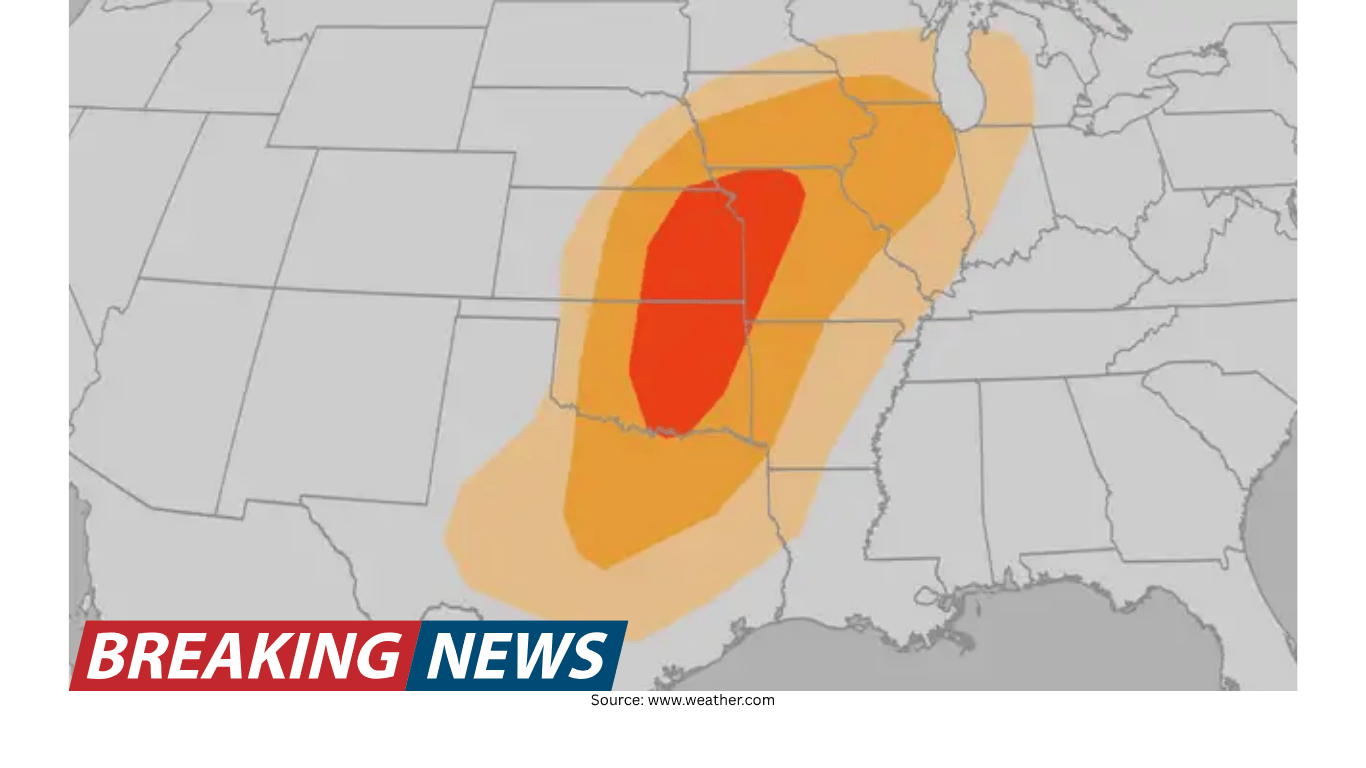
Severe storms are possible across the Plains over the next few days, and the threat could also spread into parts of the Midwest and parts of the Mississippi River Valley by mid-week. The primary hazards being monitored include hail, strong wind gusts and tornadoes. While not every community will experience severe weather, the overall pattern points to the potential for multiple days of impactful storms across a broad region.
In practical terms, this means the risk may not be confined to a single afternoon or a narrow corridor. Instead, the concern is for repeated rounds of storms that can affect travel, outdoor plans and daily routines. The geographic scope is also notable: the list of cities that could see days of severe weather includes Dallas, Oklahoma City, Kansas City, Chicago, Des Moines, Minneapolis, Detroit and St. Louis.
Where storms may develop first
The initial focus is on the Plains, where severe storms are possible over the next few days. This region often serves as a starting point for spring and early-summer storm episodes, and the current outlook highlights that the Plains could be dealing with an active stretch rather than a one-off event.
Among the major metro areas mentioned, Dallas and Oklahoma City stand out as large population centers that could be affected during the early portion of the period. Kansas City is also included among the cities that could see days of severe weather, suggesting the potential for storms to extend north and east within the broader Plains-to-Midwest corridor.
How the threat could expand by mid-week
By mid-week, the threat could spread beyond the Plains into parts of the Midwest and parts of the Mississippi River Valley. That potential expansion matters because it increases the number of communities that may need to prepare for severe weather and widens the range of travel routes and infrastructure that could be impacted.
Cities listed within the possible impact zone include Chicago, Des Moines, Minneapolis, Detroit and St. Louis. The inclusion of these metros underscores that the threat is not limited to one state or one sub-region. Instead, it may evolve over time, shifting the highest concern area from day to day as storm development changes.
Main hazards: hail, damaging winds and tornadoes
The threats include hail, wind gusts and tornadoes. Each hazard can create different kinds of disruption, and severe weather episodes often involve more than one of these impacts within the same storm system or across multiple rounds of storms.
Hail: Severe storms can produce hail that may damage vehicles, roofs and other property. Even brief hail bursts can create hazardous driving conditions.
Damaging wind gusts: Strong winds can break tree limbs, cause scattered damage and contribute to power disruptions. Wind-driven debris can also be a safety concern.
Tornadoes: Tornado potential is part of the forecast threat. Tornadoes can develop quickly and may require immediate protective action when warnings are issued.
Cities that could see days of severe weather
The forecast discussion highlights several major cities that could see days of severe weather. The phrase “days of severe weather” is important: it points to the possibility of repeated storm chances rather than a single isolated window.
Dallas
Oklahoma City
Kansas City
Chicago
Des Moines
Minneapolis
Detroit
St. Louis
Residents and travelers in and around these metro areas may want to pay close attention to daily forecast updates, since the timing and placement of the strongest storms can shift. Even within the same city, impacts can vary by neighborhood depending on where storm cells track.
What “possible” means in severe weather forecasting
Forecasts that describe severe storms as “possible” reflect the reality that storm development depends on multiple factors coming together at the right time and place. The outlook indicates a meaningful risk, but it does not guarantee that every location will see severe impacts. In multi-day setups, the threat can also fluctuate—one day may bring a higher-end event in one area, while the next day’s storms may be more scattered or displaced.
For people making plans, the key takeaway is not to assume the threat has passed after one round of storms. When the forecast suggests several days of severe potential, it can be wise to remain weather-aware throughout the period, especially during times of day when storms are most likely to develop.
Potential impacts on travel and daily routines
Severe weather hazards such as hail, strong wind gusts and tornadoes can disrupt normal routines quickly. Even when storms are brief, they can create ripple effects that last longer than the rainfall itself. Hail can make road surfaces slick and reduce visibility. Strong wind gusts can lead to sudden changes in driving conditions, particularly for high-profile vehicles. Tornado warnings can prompt temporary shutdowns of outdoor venues and interruptions to events.
Because the threat could spread from the Plains into parts of the Midwest and the Mississippi River Valley by mid-week, impacts may also affect longer-distance travel across the central U.S. People commuting between metro areas—such as between Dallas and Oklahoma City, or between St. Louis and Chicago—may encounter changing conditions over the course of the week.
Staying prepared during a multi-day threat
When several days of severe weather are possible, preparation often comes down to staying informed and being ready to act quickly if warnings are issued. While the specific storm timing may change, the hazards listed—hail, wind gusts and tornadoes—are the types of threats that can escalate rapidly.
Monitor updates: Check forecasts regularly, especially if you live in or plan to travel through the Plains, Midwest or Mississippi River Valley.
Plan for interruptions: Consider how severe weather could affect school, work commutes and outdoor activities over multiple days.
Review shelter options: Tornado potential means it is useful to know where to go if a warning is issued, whether at home, work or while traveling.
Protect vehicles when possible: Since hail is a listed threat, parking under cover when available can reduce exposure.
Why the mid-week shift matters for the Midwest and Mississippi Valley
The possibility that the threat could spread into parts of the Midwest and parts of the Mississippi River Valley by mid-week is a reminder that severe weather episodes can migrate geographically. Communities that are quiet early in the week may face a higher storm risk later, while areas that see early storms may still have additional chances afterward.
For cities like Chicago, Des Moines, Minneapolis, Detroit and St. Louis, the mid-week timeframe could coincide with typical weekday travel and school schedules, increasing the importance of having a plan for rapidly changing weather. In many severe weather situations, the difference between routine storms and dangerous storms can come down to small changes in storm intensity and track, which is why frequent updates are emphasized during active periods.
Bottom line
Severe storms are possible across the Plains over the next few days, and the threat could spread into parts of the Midwest and the Mississippi River Valley by mid-week. Hazards may include hail, damaging wind gusts and tornadoes. A number of major cities—including Dallas, Oklahoma City, Kansas City, Chicago, Des Moines, Minneapolis, Detroit and St. Louis—could see days of severe weather. The best approach during a multi-day setup is to stay alert to evolving forecasts and be ready to adjust plans as conditions change.