Severe weather threat returns for Midwest, South and parts of the East as multi-day storm system unfolds

A renewed round of severe weather
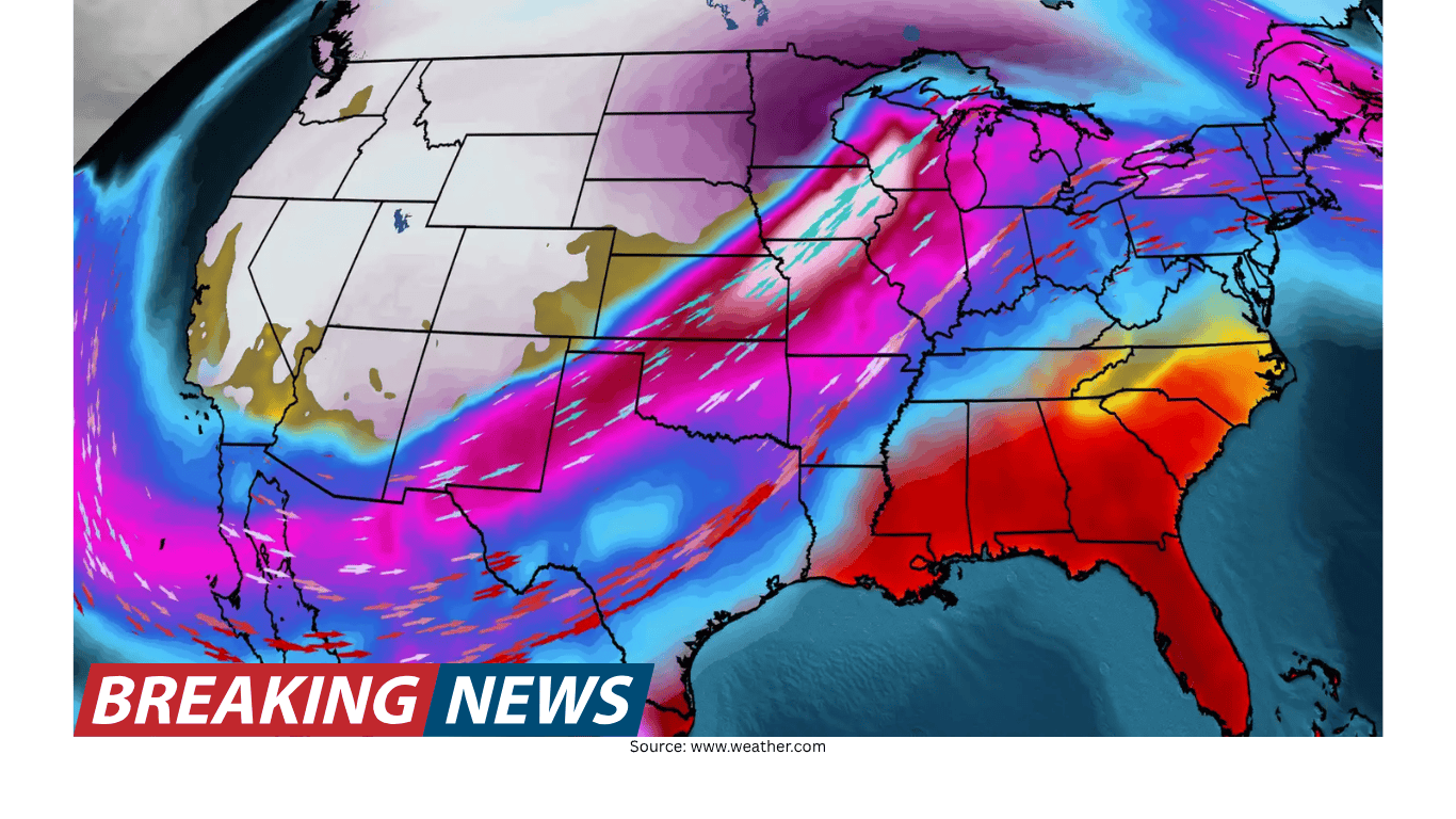
A new, multi-day period of severe weather is expected to affect wide swaths of the United States over the next three days, beginning in the Southeast and then shifting west and north. Forecasters say the pattern could bring severe thunderstorms and isolated flash flooding, with threats that include strong winds, large hail and tornadoes in some areas.
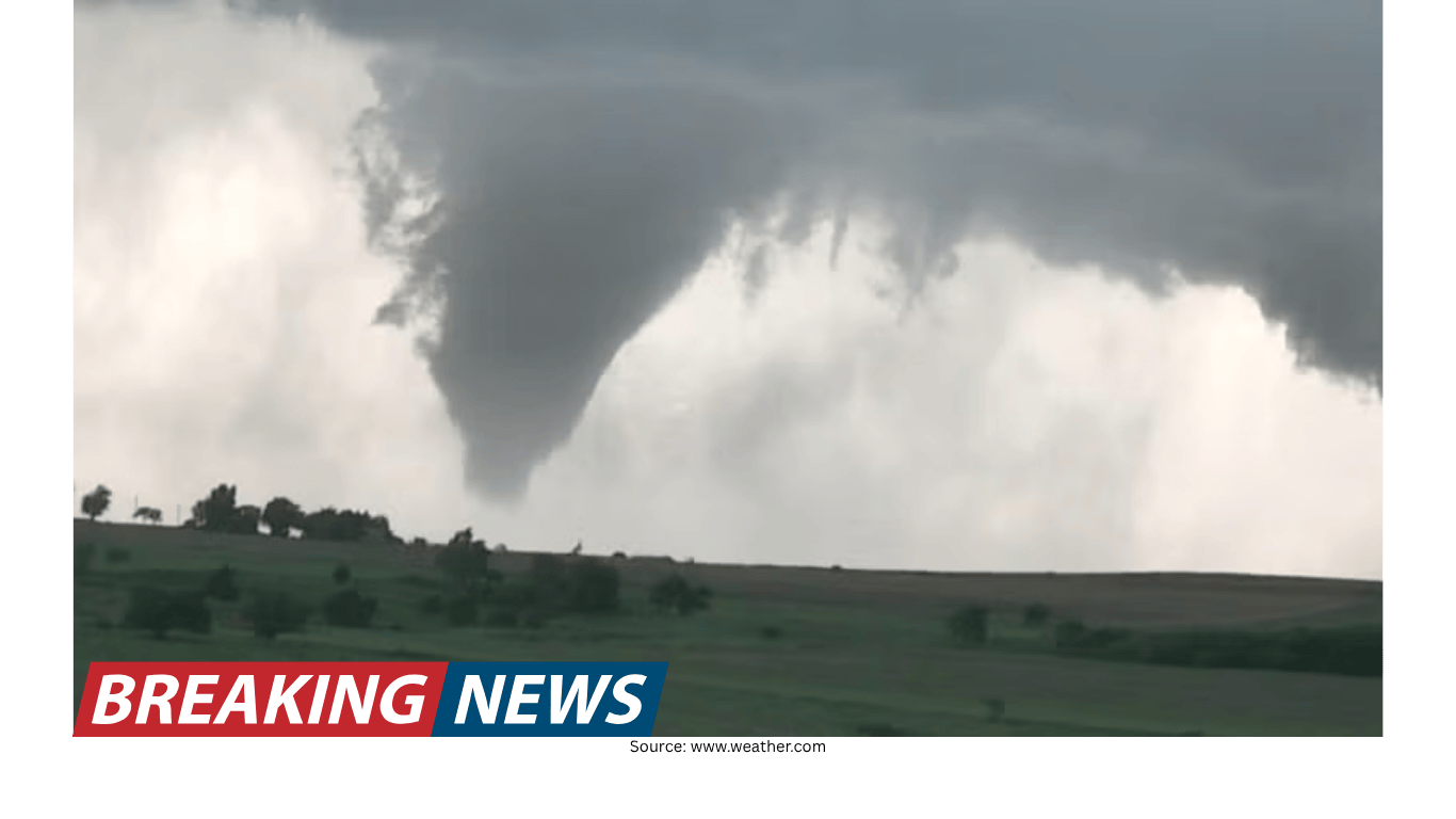
The developing storm risk comes at a difficult time for parts of the country that are still trying to recover from last week’s tornadoes in Michigan and Oklahoma, which killed six people. With additional storms possible, attention is again turning to preparedness, timing and the changing geography of the threat as the week progresses.
Monday: Southeast under a severe storm risk
On Monday, the severe weather focus is on the Southeast. About five million people were at risk for severe storms across the region, with the risk area stretching from central Arkansas to central Alabama. The main hazards highlighted for Monday include strong wind gusts, large hail and a potential tornado.
Even when storm coverage is scattered, individual cells can produce damaging impacts. Strong wind gusts can down trees and power lines, while large hail can damage roofs, vehicles and crops. The mention of a potential tornado underscores that rotating storms may develop, particularly in environments where wind patterns support rotation.
Tuesday: Midwest and southwest Texas move into the spotlight
By Tuesday, the area of greatest concern shifts. The Midwest and southwest Texas are expected to be on high alert as two clusters of storms develop. These storm clusters could bring winds up to 60 mph and the potential for flash flooding.
Wind speeds at that level can cause damage even without a tornado, particularly when storms produce widespread straight-line winds. Flash flooding can occur quickly, especially where heavy rain falls over the same locations in a short period. While flooding risk is described as isolated, it can still be dangerous in vulnerable spots such as low-lying roads and areas with poor drainage.
Midweek: a broad corridor of strong winds and a larger population at risk
As the middle of the week approaches, forecasters expect straight-line winds to become a major concern across a long corridor. The zone of risk stretches from central Pennsylvania to central Louisiana, placing about 27 million people at risk.
Straight-line winds can be particularly disruptive because they may affect a large area. They can also arrive with little warning if storms intensify rapidly. In such setups, the threat is not limited to a single community; instead, multiple cities and rural areas along the storm track may experience damaging gusts, downed trees and power interruptions.
Oklahoma braces again after a deadly tornado
Oklahoma is again preparing for severe weather only days after a devastating tornado killed a mother and daughter near Fairview. Jodie Owens, 47, and her daughter Lexi Owens, 13, were found dead in a vehicle just west of Fairview at about 10 p.m. Thursday, according to Jodie’s brother, Justin Zonts.
Zonts said the pair had been driving home after Jodie picked up Lexi from a friend’s house. After receiving a tornado warning, they rushed to get home and also called family members to urge them to take shelter.
“She’s telling them how they need to take cover. They’ve got a storm shelter put in their home. They just, they always try to be prepared,” Zonts said. “But, unfortunately, she was on the phone with her daughter just as the storm hit.”
He also emphasized a challenge that can make nighttime tornadoes especially dangerous: visibility. “A tornado at night is sometimes essentially invisible, and she had, I’m sure, no idea that was right in front of her or coming right at her from the side,” Zonts said.
He described his sister and niece as “constantly together,” adding that he joked they were attached at the hip. Zonts said Jodie and her husband, David, who have eight children, moved to Oklahoma in recent years.
The account illustrates how quickly severe weather can turn life-threatening, even for families who take preparedness seriously. It also highlights the urgency that tornado warnings can create, particularly when people are away from home and trying to reach a safer place as a storm approaches.
Michigan continues to recover after deadly tornadoes
The same tornado outbreak that struck Oklahoma also hit Michigan, where three people were killed in the Union City area. In addition, 12-year-old Silas Anderson died in Cass County, Michigan.
The superintendent of Edwardsburg Public Schools confirmed Anderson’s death in a letter to staff and families. “It is with a very heavy heart that I share the tragic passing of one of our sixth-grade students,” the letter began.
In the Union City area, the Branch County Sheriff’s Office said William Andrew Akers, 63, Keri Ann Johnson, 54, and Penni Jo Guthrie, 65, were found dead in close proximity.
As communities grieve and begin recovery efforts, the return of a severe weather threat can add stress and complicate cleanup. Damaged structures, debris and disrupted services can increase vulnerability during subsequent storms, and residents may have limited time to complete repairs before new rounds of rain and wind arrive.
What “isolated flash flooding” can mean during a multi-day event
Forecasters say severe storms and isolated flash flooding are expected across the country over the next three days. The phrase “isolated” can be misunderstood. It does not mean flooding is impossible; rather, it suggests that not every location will flood, but some may experience rapid water rises if storms repeatedly pass over the same area or if rainfall rates are intense.
In the current setup, the storm threat is not confined to a single afternoon or a single state. Instead, the risk migrates from the Southeast to other regions. That kind of multi-day pattern can create a sequence of hazards: strong winds and hail in one region, then flash flooding and damaging gusts in another, followed by a broader midweek risk as straight-line winds spread across a long corridor.
Why wind is a central concern this week
Across the forecast timeline, wind appears repeatedly as a key hazard. Monday’s storms in the Southeast include the risk of strong wind gusts. Tuesday’s storm clusters in the Midwest and southwest Texas could bring winds up to 60 mph. By midweek, straight-line winds from central Pennsylvania to central Louisiana are expected to place 27 million people at risk.
Wind damage can range from minor to severe, depending on the storm’s intensity and local conditions. Even without tornadoes, storms can produce strong gusts capable of downing limbs and trees, damaging roofs and siding, and causing power outages. When winds are widespread, they can also complicate travel and slow response efforts.
Temperature swings: warmth returns to the East Coast
While severe storms draw attention across parts of the South and Midwest, the East Coast is experiencing a different kind of weather story: a return to warmer temperatures after a bitterly cold winter.
New York City reached 69 degrees on Sunday, marking the first 60-degree day since early November. The warm reading ended the city’s longest stretch of consecutive days below 60 degrees since the winter of 1981 to 1982.
Farther south, Tampa hit 90 degrees on Sunday, setting the city’s earliest 90-degree day on record.
These temperature milestones underscore how different weather patterns can unfold simultaneously across the country. Warmth on the East Coast does not eliminate storm risk elsewhere, and shifting seasonal conditions can bring rapid changes from one week to the next.
Staying oriented as the threat shifts day by day
One challenge in a multi-day severe weather setup is that the most significant risk area changes over time. Monday’s focus is the Southeast, from central Arkansas to central Alabama. Tuesday shifts the concern to the Midwest and southwest Texas. By midweek, the risk expands across a large corridor from central Pennsylvania to central Louisiana.
Because the threat is spread out in both time and geography, people may need to pay attention not only to the day’s forecast but also to what is expected next. A location that is quiet on Monday could face a higher risk on Tuesday or Wednesday, and areas that experienced storms earlier may still be dealing with the after-effects when the next round arrives.
Key points from the forecast timeline
Next three days: Severe storms and isolated flash flooding are expected across the country, beginning in the Southeast.
Monday: About five million people are at risk across the Southeast, from central Arkansas to central Alabama, with threats including strong wind gusts, large hail and a potential tornado.
Tuesday: The Midwest and southwest Texas are on high alert as two storm clusters could bring up to 60 mph winds and flash flooding.
Midweek: Straight-line winds from central Pennsylvania to central Louisiana could put 27 million people at risk.
Ongoing recovery: The renewed threat comes as communities in Michigan and Oklahoma recover from last week’s deadly tornadoes that killed six people.
A week shaped by both risk and recovery
This week’s forecast combines two realities: the immediate need to monitor new storm threats and the longer process of recovering from recent tornado damage and loss of life. In Oklahoma, the deaths of Jodie and Lexi Owens near Fairview have added urgency to renewed warnings. In Michigan, communities are mourning those killed in the Union City area and the death of a 12-year-old student in Cass County.
At the same time, the East Coast’s warm-up offers a reminder that weather can shift quickly, sometimes dramatically, across regions. From record-setting warmth in Tampa to the end of a long cool stretch in New York City, the country is seeing a wide range of conditions even as severe storms remain a central concern elsewhere.
With the risk expected to evolve over several days, the most important takeaway is that the threat is not confined to one place or one moment. The forecast calls for changing storm corridors, a recurring wind hazard, and pockets of flash flooding potential—conditions that can develop quickly and demand close attention as the week unfolds.
Related Articles